Forum rules
Queensland specific bushwalking discussion. Please avoid publishing details of access to sensitive areas with no tracks.Kuranda to Speewah Camping Ground
Sun 03 Apr, 2011 9:13 pm
Hi. I am planning my three night camping trip to Speewah Camping Ground. I am starting off at Kuranda in the town.
As my name says, I walk on foot, and that is my only way to go from Kuranda, Here is the main places I will walk..
Get a bus to Kuranda from Cairns City - I can get a $4 one way bus ticket there. Stop off for any supplies I have forgotten or think of.
Walk by the side of Barron Falls Road..yeah not relaxing or pretty .... yet
then walk to Wrights Lookout
then on the McDonalds Track - a 4wd track
until at Red Bluff
then onto the Douglas Track
and then the Djina-wu track
to reach the Speewah campground.
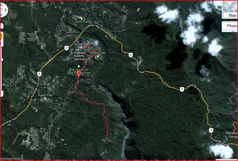
Here is a map of the area with my planned journey shown in red.

I will then stay at the camping ground for three nights. I am local to the area, and want to get into some nature time and just do things without stress and all the mundane stuff. I work my own hours as an artist and musician, so I can go quite freely.
I'll report on my journey with photos and such once I return. I have never been on the walks here, I used to live in the Blue Mountains, so I am used to hills, and can handle a bit of the cool weather and rain. I also grew up in Turramurra on the North Shore in NSW, so again, I am used to hills.
If anyone does know of the approximate journey time going on the map, and my trail, then please let me know! Also any other factors to take into consideration, such as the campsite fee, permit etc..water...
Blessings
Samantha
As my name says, I walk on foot, and that is my only way to go from Kuranda, Here is the main places I will walk..
Get a bus to Kuranda from Cairns City - I can get a $4 one way bus ticket there. Stop off for any supplies I have forgotten or think of.
Walk by the side of Barron Falls Road..yeah not relaxing or pretty .... yet
then walk to Wrights Lookout
then on the McDonalds Track - a 4wd track
until at Red Bluff
then onto the Douglas Track
and then the Djina-wu track
to reach the Speewah campground.
Here is a map of the area with my planned journey shown in red.
I will then stay at the camping ground for three nights. I am local to the area, and want to get into some nature time and just do things without stress and all the mundane stuff. I work my own hours as an artist and musician, so I can go quite freely.
I'll report on my journey with photos and such once I return. I have never been on the walks here, I used to live in the Blue Mountains, so I am used to hills, and can handle a bit of the cool weather and rain. I also grew up in Turramurra on the North Shore in NSW, so again, I am used to hills.
If anyone does know of the approximate journey time going on the map, and my trail, then please let me know! Also any other factors to take into consideration, such as the campsite fee, permit etc..water...
Blessings
Samantha
Re: Kuranda to Speewah Camping Ground
Sun 03 Apr, 2011 10:17 pm
And this is the first leg of the journey, so not unpleasant. Viewed on Google Maps with the Satellite option. I then took a screenshot with the snipping tool, and coloured the journey in red in photoshop. Saved the file and uploaded it to photobucket.
My alternative option is to walk along the Kennedy Highway from Kuranda to Speewah campground, which will not take as long, for the initial night to ensure I can set up the tent. And then go for walks, either the same day or the next days.
My alternative option is to walk along the Kennedy Highway from Kuranda to Speewah campground, which will not take as long, for the initial night to ensure I can set up the tent. And then go for walks, either the same day or the next days.
Last edited by twowalkonfoot on Mon 04 Apr, 2011 5:07 pm, edited 1 time in total.
Re: Kuranda to Speewah Camping Ground
Mon 04 Apr, 2011 4:18 pm
Here is an answer from Kuranda Visitor Information Centre by email..She also welcomes any feedback from walkers about the area..
As the campground is self registering once you get there, you will just have to take your chance with bookings. Over the Easter weekend you might find it busy, but if you only have a tent you could pitch it anywhere really. I have attached the barron gorge map for your information. As there was some damage after the cyclone, I would recommend checking with National Parks for updates on the walking tracks http://www.derm.qld.gov.au/parks/barron ... index.html
It is 9.9km and takes roughly 6-7 hours from Wrights Lookout to Speewah Campground. It would take an hour and half to walk from Kuranda to Wrights Lookout. We really would recommend you walk with someone as it might be quite dark towards the end of the walk and probably not very safe.
If you need any more information, please contact National Parks as they will be able to give you further information about the park at the moment.
Re: Kuranda to Speewah Camping Ground
Tue 05 Apr, 2011 6:49 pm
First few times I visited Kuranda ('85-'90, I think) it was possible to walk along the rail line. Some great views, but you did have to keep a good lookout for trains . . .
Re: Kuranda to Speewah Camping Ground
Sat 09 Apr, 2011 12:15 am
H  mm not sounding like a fun thing to do. A friend of mine was killed because he walked on train tracks in between train stations. He was hit by a train on the head with enough impact to kill him instantly. I'm put off walking on train tracks for life from that.
Re: Kuranda to Speewah Camping Ground
Sun 10 Apr, 2011 7:21 pm
Oh, you can't do it any more, haven't been able to for years now, the access was fenced off ages ago. A pity, really. Can't even get to the falls from the train line, and that used to be a lovely little scramble.
Re: Kuranda to Speewah Camping Ground
Sun 10 Apr, 2011 9:56 pm
Hi Samantha,
A few years ago now I did a walk up there which covered a fair bit of your walk. I used to live up there but now only ever travel up to visit in inlaws.
If you didn't want to have to do the roadside walk, you could always consider starting from Stoney Creek and walking up. There are a few steep bits but it's a good walk. You cross the train line at Red Bluff.
The walk I did started at Stoney Creek, went up past Glacier Rock, then took the Gandal Wundun shortcut to Smiths Track and then back down to Kamerunga (then walked back to Redlynch). We did that in about 6 hours with a couple of stops. We certainly made good time as the track is pretty easy going and once you've climbed to Glacier Rock, it's pretty flat.
Looking forwards to a trip report and some pics!
Joel
© Bushwalk Australia and contributors 2007-2013.