It is my understanding that it's a raster based map,
although it has contours, they become pixellated as you zoom.
Mine starts with sat imagery, and draws vector data over it,
and that's how it knows your proximity with regard to trails,
roads, POIs, and contours.
I don't think you'll get the digital data.. AFAIK there isn't any.
The digital maps for sale are imagery of the same paper maps.
I had to calibrate and trace the raster data into a vector program myself.
I saw what it looked like overlaying satellite imagery four years later.
To cover Australia that way would be an immense task though!
Mount Barney routes
Forum rules
Queensland specific bushwalking discussion. Please avoid publishing details of access to sensitive areas with no tracks.
Queensland specific bushwalking discussion. Please avoid publishing details of access to sensitive areas with no tracks.
Re: Mount Barney routes
![]() by Art » Tue 23 Apr, 2013 9:26 pm
by Art » Tue 23 Apr, 2013 9:26 pm
- Art
- Nothofagus gunnii

- Posts: 32
- Joined: Sun 14 Apr, 2013 12:19 am
- Region: Queensland
Re: Mount Barney routes
![]() by Art » Wed 24 Apr, 2013 4:58 pm
by Art » Wed 24 Apr, 2013 4:58 pm
Only fair to post as Human, and try to return on some of the pics posted here.
Winner for me so far is def color picture of Old Hut.

East Barney Viewed from Montserrat.
Normally, the direct route from East Peak to Montserrat is dangerous,
but the cloud was very thick, and I walked straight across it.
I got many frames of identical quality for this, but I kept the fly.
(see the fly at the bottom? It's not a helicopter).

Now that my integrity is shot, I have to ask you to believe this photo is
lit by controlled fire, not by the Sun at all. This is true!

I thought that Focal Peak's presence on the map would make it spectacular.
Well it is, but the journey is in this case more interesting than the destination
when you are actually there. The area is disturbed far less often,
and I found a Bower right on the trail
Cheers, Brek.
Winner for me so far is def color picture of Old Hut.
East Barney Viewed from Montserrat.
Normally, the direct route from East Peak to Montserrat is dangerous,
but the cloud was very thick, and I walked straight across it.
I got many frames of identical quality for this, but I kept the fly.
(see the fly at the bottom? It's not a helicopter).
Now that my integrity is shot, I have to ask you to believe this photo is
lit by controlled fire, not by the Sun at all. This is true!
I thought that Focal Peak's presence on the map would make it spectacular.
Well it is, but the journey is in this case more interesting than the destination
when you are actually there. The area is disturbed far less often,
and I found a Bower right on the trail
Cheers, Brek.
- Art
- Nothofagus gunnii
- Posts: 32
- Joined: Sun 14 Apr, 2013 12:19 am
- Region: Queensland
Re: Mount Barney routes
![]() by gbagua » Thu 25 Apr, 2013 11:48 am
by gbagua » Thu 25 Apr, 2013 11:48 am
Art wrote:For those of you who are reading this, I wrote a GPS program over the last four years based
on Mt Barney National Park. It's iPhone version is not quite out yet at the time of posting this,
but is very close
http://www.freewebs.com/defxev/AVECios.htm
Hi there,
Any idea when is the iPhone app. going to be released?
Thanks.
-
gbagua - Phyllocladus aspleniifolius

- Posts: 513
- Joined: Sat 20 Oct, 2012 9:04 pm
- Region: Queensland
Re: Mount Barney routes
![]() by Art » Thu 25 Apr, 2013 2:33 pm
by Art » Thu 25 Apr, 2013 2:33 pm
It is already released by me, and approved by Apple.
It's in a status called "Processing for the App Store",
which is supposed to progress within 24 hrs, but it has been about 24 hrs
EDIT,,, it is up.. you can search for "Mt Barney", or "AVEC GPS".
It's in a status called "Processing for the App Store",
which is supposed to progress within 24 hrs, but it has been about 24 hrs
EDIT,,, it is up.. you can search for "Mt Barney", or "AVEC GPS".
- Art
- Nothofagus gunnii
- Posts: 32
- Joined: Sun 14 Apr, 2013 12:19 am
- Region: Queensland
Re: Mount Barney routes
![]() by gbagua » Fri 26 Apr, 2013 1:25 pm
by gbagua » Fri 26 Apr, 2013 1:25 pm
Cool! Just released by Apple, so all good.
Here's the link:
https://itunes.apple.com/au/app/avec-gp ... mpt=uo%3D2
Cheers.
Here's the link:
https://itunes.apple.com/au/app/avec-gp ... mpt=uo%3D2
Cheers.
-
gbagua - Phyllocladus aspleniifolius
- Posts: 513
- Joined: Sat 20 Oct, 2012 9:04 pm
- Region: Queensland
Re: Mount Barney routes
![]() by Art » Fri 26 Apr, 2013 7:02 pm
by Art » Fri 26 Apr, 2013 7:02 pm
Be sure to give me an honest review!
Unless you're using an iPhone 4 or prior... then forget the link!!!
Unless you're using an iPhone 4 or prior... then forget the link!!!
- Art
- Nothofagus gunnii
- Posts: 32
- Joined: Sun 14 Apr, 2013 12:19 am
- Region: Queensland
Re: Mount Barney routes
![]() by findbuddha » Fri 19 Jul, 2013 12:59 pm
by findbuddha » Fri 19 Jul, 2013 12:59 pm
Is there a recommended route between Mt Maroon and Lower Portals? I'm thinking of camping at Paddy's plain. Looks like there is a bit of private property between the two sections of NP? Or is the best option via either Drynan's Hut Rd or Seidenspinner Rd to Lower Portals Carpark then use the track?
Cheers
Cheers
- findbuddha
- Athrotaxis cupressoides

- Posts: 114
- Joined: Mon 26 Nov, 2012 5:33 pm
- Region: Queensland
Re: Mount Barney routes
![]() by gbagua » Wed 07 Aug, 2013 8:57 am
by gbagua » Wed 07 Aug, 2013 8:57 am
I did Logan's last Sunday and it was fun. Weather was just perfect. Next is the North Ridge. Can anyone point me in the right direction as I am not quite sure where the hiking trail would run on it. I have attached a photo with what I think is the north ridge (Logan's is marked in red):

Cheers!

Cheers!
-
gbagua - Phyllocladus aspleniifolius
- Posts: 513
- Joined: Sat 20 Oct, 2012 9:04 pm
- Region: Queensland
Re: Mount Barney routes
![]() by gbagua » Thu 26 Sep, 2013 12:41 pm
by gbagua » Thu 26 Sep, 2013 12:41 pm
Blue line (North Ridge) was OK. Here's a more accurate line (green) of the original pic.

Added to the database.

Added to the database.
-
gbagua - Phyllocladus aspleniifolius
- Posts: 513
- Joined: Sat 20 Oct, 2012 9:04 pm
- Region: Queensland
Re: Mount Barney routes
![]() by antsrealm » Sat 19 Oct, 2013 1:59 pm
by antsrealm » Sat 19 Oct, 2013 1:59 pm
Hi guys, fairly new to the forum. We are looking to go up Mount Barney next month in a group of around 5 camping at the rum jungle and coming back down via peasants. I have been up peasants before with packs and also up Logans before with overnight packs (Oops). We weren't ready for what we found on Logans and one of mates was practically in tears with fear when he had to traverse some of those exposed sections.
I was looking to take an alternate path up to peasants as we have done that before but there are certain people in the group that would not feel comfortable if there was a chance they could slip, fall and die.
Is there any tracks you guys would recommend. I was thinking SE ridge but am concerned about the ledge over the east face with a 300m drop. That probably wont go down to well.
Any recommendations ??
Also does anyone have any photos of that ledge ?
Thanks
- antsrealm
- Nothofagus gunnii
- Posts: 34
- Joined: Wed 16 Oct, 2013 9:43 am
- Region: Queensland
- Gender: Male
Re: Mount Barney routes
![]() by Pteropus » Sun 20 Oct, 2013 2:16 pm
by Pteropus » Sun 20 Oct, 2013 2:16 pm
Hi antsrealm. I don't recall anything too hairy on the SE ridge. Of course the track does get close to cliff lines in places, but I think you would need to physically hurl yourself over to fall off there. I think this pic is taken from one of the cliffiest parts of the track.
I don't remember any climbing above the drop though.
There are however, some very steep sections which are obviously risky. See these pics for example -> viewtopic.php?f=38&t=4871&start=90#p154730
But its just general rock scrambling and I don't recall terrible exposure. Might be very tough on your legs with an overnight pack though. I had a day pack with perhaps 2-4 litres of water + maybe 3 kg of camera, and my legs did suffer a few cramps. But apart from that, it was not too bad.
- Pteropus
- Athrotaxis selaginoides

- Posts: 1051
- Joined: Sun 09 May, 2010 6:42 pm
- Location: Neither here nor there
- Region: Australia
- Gender: Male
Re: Mount Barney routes
![]() by gbagua » Sun 20 Oct, 2013 2:17 pm
by gbagua » Sun 20 Oct, 2013 2:17 pm
Go up the SE Ridge, the ledge is not really that close to the drop. It's a lot easier than Logan's especially on the way up. Just keep an eye on your friends (assistance and reassuring they will be OK) and they'll manage.
-
gbagua - Phyllocladus aspleniifolius
- Posts: 513
- Joined: Sat 20 Oct, 2012 9:04 pm
- Region: Queensland
- antsrealm
- Nothofagus gunnii
- Posts: 34
- Joined: Wed 16 Oct, 2013 9:43 am
- Region: Queensland
- Gender: Male
Re: Mount Barney routes
![]() by gav » Sat 14 Dec, 2013 10:19 am
by gav » Sat 14 Dec, 2013 10:19 am
gbagua wrote:Go up the SE Ridge, the ledge is not really that close to the drop.
I disagree.
From http://www.southee.com/Bushwalking/Ch13 ... l#label050 "...care is required in one brief section where you scramble upwards for perhaps four or five steps immediately above the east face. Although the section is so easy and quick that few people even notice the drop below, care is required. There is little scrub between you and the cliff edge at this point and any mistake could lead to a fall of some 300m."
This movie (not mine) shows the section from 13:50 to 14:10 http://youtu.be/nhIhLKBdHQI?t=13m50s
- gav
- Nothofagus cunninghamii

- Posts: 2
- Joined: Sun 13 Oct, 2013 7:54 am
- Region: New South Wales
- Gender: Male
Re: Mount Barney routes
![]() by Art » Tue 04 Feb, 2014 4:33 pm
by Art » Tue 04 Feb, 2014 4:33 pm
Hi Guys,
Does anyone know if Drynan's Hut is still on the property?
Apparently back in the day, you crossed Drynan's property to get to Lower Portals, and could sleep in the hut.
This photo:
"Arthur Mallinson helps Jim Drynan to move his hut on the back of his Morris truck in 1953"
I don't actually know if this is when the hut is moved to, or away from the area.
Does anyone know if Drynan's Hut is still on the property?
Apparently back in the day, you crossed Drynan's property to get to Lower Portals, and could sleep in the hut.
- Moving hut on a Morris truck in the Beaudesert area 1953.jpg (55.5 KiB) Viewed 54463 times
This photo:
"Arthur Mallinson helps Jim Drynan to move his hut on the back of his Morris truck in 1953"
I don't actually know if this is when the hut is moved to, or away from the area.
- Art
- Nothofagus gunnii
- Posts: 32
- Joined: Sun 14 Apr, 2013 12:19 am
- Region: Queensland
Re: Mount Barney routes
![]() by tomh » Tue 04 Feb, 2014 7:58 pm
by tomh » Tue 04 Feb, 2014 7:58 pm
The subject of Drynan's hut has been discussed previously in this thread.
There is still a hut on the property at about the same location indicated on the Maroon topo map (727 761) but it's not the one in your photo.
A photo of the current hut (if it hasn't been changed again more recently than 2/2011 and yes this is the one I have walked past next to the creek) is at
http://www.flickr.com/photos/imagementor4/5591027159/
and the the title states 'Drynan's Hut 3' - third hut or photo no. 3?
and someone is posing in a supposedly private hut. The photographer could possibly provide more information.
- tomh
- Athrotaxis cupressoides
- Posts: 157
- Joined: Wed 02 Jun, 2010 3:44 pm
- Region: Queensland
- Gender: Male
Re: Mount Barney routes
![]() by Art » Sat 15 Feb, 2014 11:16 pm
by Art » Sat 15 Feb, 2014 11:16 pm
Thanks for the info, and sorry, I missed it!
I also hear of another hut which may no longer be present that was maintained by some Catholic bushwalking club.
This is supposed to be somewhere near the creek, after a fair part of the walk in, but I've never seen it in some 20 years.
Then again, I only ever knew about Drynan's Hut from the maps.
I also hear of another hut which may no longer be present that was maintained by some Catholic bushwalking club.
This is supposed to be somewhere near the creek, after a fair part of the walk in, but I've never seen it in some 20 years.
Then again, I only ever knew about Drynan's Hut from the maps.
- Art
- Nothofagus gunnii
- Posts: 32
- Joined: Sun 14 Apr, 2013 12:19 am
- Region: Queensland
Re: Mount Barney routes
![]() by tas-man » Wed 19 Feb, 2014 11:05 pm
by tas-man » Wed 19 Feb, 2014 11:05 pm
Art wrote:I also hear of another hut which may no longer be present that was maintained by some Catholic bushwalking club.
This is supposed to be somewhere near the creek, after a fair part of the walk in, but I've never seen it in some 20 years.
Then again, I only ever knew about Drynan's Hut from the maps.
I posted this 1970 photo of the Catholic Bushwalkers Hut on page 2 of this topic - download/file.php?id=7055&mode=view
I take it that it still exists?
"The world reveals itself to those who travel on foot."
Werner Herzog
Werner Herzog
-

tas-man - Athrotaxis selaginoides
- Posts: 1469
- Joined: Mon 03 Sep, 2007 8:55 pm
- Location: Riverside
- Region: Tasmania
- Gender: Male
Re: Mount Barney routes
![]() by facebox » Thu 20 Feb, 2014 4:47 pm
by facebox » Thu 20 Feb, 2014 4:47 pm
tas-man wrote:Art wrote:I also hear of another hut which may no longer be present that was maintained by some Catholic bushwalking club.
This is supposed to be somewhere near the creek, after a fair part of the walk in, but I've never seen it in some 20 years.
Then again, I only ever knew about Drynan's Hut from the maps.
I posted this 1970 photo of the Catholic Bushwalkers Hut on page 2 of this topic - download/file.php?id=7055&mode=view
I take it that it still exists?
Yes, Catholic bushwalkers hut still exists, was there last month, still in good condition. Old style access was to turn right where the ??Eagles ridge tracks leaves the lower portals track, just before the 2nd gate. However, access to the hut is now north of the lower portals camp and across the creek. Access from the lower portals track is impossible due to lantana.
There is generally catholic mass once a year atleast.
- facebox
- Nothofagus gunnii
- Posts: 19
- Joined: Fri 25 Jun, 2010 8:13 am
- Location: Brisbane
- Region: Queensland
- Gender: Male
Re: Mount Barney routes
![]() by Art » Wed 02 Apr, 2014 12:11 pm
by Art » Wed 02 Apr, 2014 12:11 pm
Thanks for the info.. If anyone visits again in the coming weeks, I'd appreciate some coordinates.
Some medical issues here are preventing me from doing any big walks, so checking out the hut seems like some fun.
Cheers, Art.
Some medical issues here are preventing me from doing any big walks, so checking out the hut seems like some fun.
Cheers, Art.
- Art
- Nothofagus gunnii
- Posts: 32
- Joined: Sun 14 Apr, 2013 12:19 am
- Region: Queensland
Re: Mount Barney routes
![]() by phan_TOM » Mon 28 Apr, 2014 4:24 pm
by phan_TOM » Mon 28 Apr, 2014 4:24 pm
I had my first visit to Barney on the weekend, staying a night at rum jungle and climbing up to east peak for the sunrise in the morning. It was a fun walk, not too many people were out and the weather was sparkling.
I woke up at 5am on Sunday and headed up East Peak in the dark to catch the sunrise. I left straight from rum jungle, as it looks like there's a fairly decent track, which then disappears into scrub after about 25 metres, and just contoured east along that ridge through the scrub and then scrambled to the top. It was only on my way back that I found the well taped and fairly well worn foot pad all the way back to the old hut site! Typical but it was a fun way to start the day
South Ridge (Peasants) does feel a bit like the tourist route and the number of significantly older people that I passed who had gone up the SE ridge had me wishing that I hadn't been such a wuss and gone that way anyway. Oh well, It's on the list for next time.
- the eastern face
- 01.jpg (60.76 KiB) Viewed 53690 times
- about half way up
- 02.jpg (137.14 KiB) Viewed 53690 times
- Mt Lindesay
- 03.jpg (103.8 KiB) Viewed 53690 times
- 04.jpg (104.03 KiB) Viewed 53690 times
ALWAYS be yourself.
Unless you can be outside, then ALWAYS be outside.
Unless you can be outside, then ALWAYS be outside.
-

phan_TOM - Phyllocladus aspleniifolius
- Posts: 661
- Joined: Sat 21 Aug, 2010 5:27 pm
- Region: New South Wales
- Gender: Male
a couple more
![]() by phan_TOM » Mon 28 Apr, 2014 4:27 pm
by phan_TOM » Mon 28 Apr, 2014 4:27 pm
- west peak
- 06.jpg (119.11 KiB) Viewed 53689 times
- sunrise
- 08.jpg (129.21 KiB) Viewed 53689 times
- 09.jpg (140.24 KiB) Viewed 53689 times
ALWAYS be yourself.
Unless you can be outside, then ALWAYS be outside.
Unless you can be outside, then ALWAYS be outside.
-
phan_TOM - Phyllocladus aspleniifolius
- Posts: 661
- Joined: Sat 21 Aug, 2010 5:27 pm
- Region: New South Wales
- Gender: Male
Re: Mount Barney routes
![]() by tas-man » Tue 29 Apr, 2014 1:53 am
by tas-man » Tue 29 Apr, 2014 1:53 am
phan_TOM wrote:I had my first visit to Barney on the weekend, staying a night at rum jungle and climbing up to east peak for the sunrise in the morning. It was a fun walk, not too many people were out and the weather was sparkling. <SNIP>
What a fabulous first experience of Barney - - the morning light made for some great photography. Thanks for sharing!
"The world reveals itself to those who travel on foot."
Werner Herzog
Werner Herzog
-
tas-man - Athrotaxis selaginoides
- Posts: 1469
- Joined: Mon 03 Sep, 2007 8:55 pm
- Location: Riverside
- Region: Tasmania
- Gender: Male
Re: Mount Barney routes
![]() by phan_TOM » Tue 29 Apr, 2014 9:48 am
by phan_TOM » Tue 29 Apr, 2014 9:48 am
The scramble up the mountain for the sunrise turned out to be the highlight of my trip. And to think I almost went back to bed after checking the sky and seeing a blanket of low clouds in the pre-dawn sky. You can never tell what it's going to do.
I was actually still 5 minutes from the top, hidden from the view on the west side of east peak, when the sun crested the horizon and the whole sky turned into a thick haze of red light. By the time I'd reached the high point and pulled my camera out it had faded back to what you see in the photos.
I was actually still 5 minutes from the top, hidden from the view on the west side of east peak, when the sun crested the horizon and the whole sky turned into a thick haze of red light. By the time I'd reached the high point and pulled my camera out it had faded back to what you see in the photos.
ALWAYS be yourself.
Unless you can be outside, then ALWAYS be outside.
Unless you can be outside, then ALWAYS be outside.
-
phan_TOM - Phyllocladus aspleniifolius
- Posts: 661
- Joined: Sat 21 Aug, 2010 5:27 pm
- Region: New South Wales
- Gender: Male
Re: Mount Barney routes
![]() by cams » Tue 29 Apr, 2014 12:35 pm
by cams » Tue 29 Apr, 2014 12:35 pm
phan_TOM wrote:The scramble up the mountain for the sunrise turned out to be the highlight of my trip. And to think I almost went back to bed after checking the sky and seeing a blanket of low clouds in the pre-dawn sky. You can never tell what it's going to do.
I was actually still 5 minutes from the top, hidden from the view on the west side of east peak, when the sun crested the horizon and the whole sky turned into a thick haze of red light. By the time I'd reached the high point and pulled my camera out it had faded back to what you see in the photos.
I nearly commented when I saw your sunrise pic that it looks like it would have been one of those amazing blanket sunrises. That is still my favourite of the set though. I'm a sucker for those hazy mountain ridges fading into the distance.
-
cams - Phyllocladus aspleniifolius
- Posts: 725
- Joined: Tue 24 Aug, 2010 1:54 pm
- Region: Tasmania
- Gender: Male
Re: Mount Barney routes
![]() by Art » Sat 10 May, 2014 12:28 am
by Art » Sat 10 May, 2014 12:28 am
Yes nice one.. a lot of the other photos look familiar and simlilar to my own,
but that one sure looks an amazing view.
but that one sure looks an amazing view.
- Art
- Nothofagus gunnii
- Posts: 32
- Joined: Sun 14 Apr, 2013 12:19 am
- Region: Queensland
Re: Mount Barney routes
![]() by gbagua » Thu 18 Dec, 2014 2:45 pm
by gbagua » Thu 18 Dec, 2014 2:45 pm
I'm planning to to Long Leaning Ridge but can't find much info on it aside from what is described in here and here.
Any other sources like a contour line to give me an idea where the ridge starts and runs exactly on an image:
Here's one.
Hate being 'bushwhacked' especially in an area like Barney where trips are looooong.
Note:
I just found this photo of the old rapelling anchor at Leaning Peak. Holy mother of god, what an utter mess! It's just insane relying on that plus the thin dead bushes as themain protection. Suicidal! Fortunately that has been replaced with bolts as mentioned in the second link.
More info about how to set up correctly a rapelling anchor in this link.
-
gbagua - Phyllocladus aspleniifolius
- Posts: 513
- Joined: Sat 20 Oct, 2012 9:04 pm
- Region: Queensland
Re: Mount Barney routes
![]() by gbagua » Mon 13 Aug, 2018 6:35 pm
by gbagua » Mon 13 Aug, 2018 6:35 pm
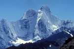
Before this thread falls into oblivion, here's a picture of the Barney massif taken from Mt May's summit. It was yesterday on a clear crisp day. The wind helped removing any traces of haze/fog/low cloud.

-
gbagua - Phyllocladus aspleniifolius
- Posts: 513
- Joined: Sat 20 Oct, 2012 9:04 pm
- Region: Queensland
Re: Mount Barney routes
![]() by ofuros » Mon 13 Aug, 2018 6:48 pm
by ofuros » Mon 13 Aug, 2018 6:48 pm
Nice one gbagua...so many routes so little time. 
Mountain views are good for my soul...& getting to them is good for my waistline !
https://ofuros.exposure.co/
https://ofuros.exposure.co/
-

ofuros - Athrotaxis selaginoides
- Posts: 1935
- Joined: Fri 05 Feb, 2010 4:42 pm
- Region: Queensland
- Gender: Male
Re: Mount Barney routes
![]() by gbagua » Tue 21 Aug, 2018 4:03 pm
by gbagua » Tue 21 Aug, 2018 4:03 pm
Yes too many routes!
If someone could provide some bearings to the start of the NE Ridge, it would be great.
We'll be returning via Rocky Creek after a nice scramble up to North Peak. It should be fun.
Cheers.
If someone could provide some bearings to the start of the NE Ridge, it would be great.
We'll be returning via Rocky Creek after a nice scramble up to North Peak. It should be fun.
Cheers.
-
gbagua - Phyllocladus aspleniifolius
- Posts: 513
- Joined: Sat 20 Oct, 2012 9:04 pm
- Region: Queensland
Who is online
Users browsing this forum: No registered users and 9 guests