Logan's ridge is easier and less exposed than I had been led to believe (did it the other weekend). There are a few false tracks that can slow you down finding the route in places but if you knew the route, were reasonably fit and had a light pack - up and back down SE or peasants would not be too bad in a day. I wouldn't rate Logan's as much harder or more exposed than SE if you are half comfortable with scrambling on rock.
IMO Eagles remains the stand-out Barney route - not necessarily hard again in terms of scrambling skills but longer, more exposed and better / more consistent views. Up Eagles and down in a day i have never attempted. It would be good prep for Federation I expect.
Mount Barney routes
Forum rules
Queensland specific bushwalking discussion. Please avoid publishing details of access to sensitive areas with no tracks.
Queensland specific bushwalking discussion. Please avoid publishing details of access to sensitive areas with no tracks.
Re: Mount Barney routes
![]() by nq111 » Wed 10 Aug, 2011 6:05 pm
by nq111 » Wed 10 Aug, 2011 6:05 pm
-
nq111 - Phyllocladus aspleniifolius

- Posts: 932
- Joined: Mon 07 Mar, 2011 8:27 pm
- Region: Queensland
Re: Mount Barney routes
![]() by tas-man » Wed 10 Aug, 2011 11:46 pm
by tas-man » Wed 10 Aug, 2011 11:46 pm
nq111 wrote:<Snip>IMO Eagles remains the stand-out Barney route - not necessarily hard again in terms of scrambling skills but longer, more exposed and better / more consistent views. Up Eagles and down in a day i have never attempted. It would be good prep for Federation I expect.
I would agree with you that Eagles is the most satisfying route up Barney I ever did, for the unfolding views of the Barney massif and variety of terrain you cover. It was a LONG day, and we camped at Rum Jungle after descending from East Peak at dusk. There are some photos of Eagles that I posted earlier in this thread.
"The world reveals itself to those who travel on foot."
Werner Herzog
Werner Herzog
-

tas-man - Athrotaxis selaginoides

- Posts: 1477
- Joined: Mon 03 Sep, 2007 8:55 pm
- Location: Riverside
- Region: Tasmania
- Gender: Male
Re: Mount Barney routes
![]() by kyle » Wed 24 Aug, 2011 4:54 pm
by kyle » Wed 24 Aug, 2011 4:54 pm
Anyone done Cronans Creek/Yellowpinch to the Lower Portals without going over Barney?
- kyle
- Nothofagus gunnii

- Posts: 26
- Joined: Sun 12 Jun, 2011 5:58 pm
- Region: Queensland
Re: Mount Barney routes
![]() by isoma » Thu 25 Aug, 2011 2:30 pm
by isoma » Thu 25 Aug, 2011 2:30 pm
If you just mean avoid going over East Peak then yes there are plenty of routes. But I suspect you mean avoiding all routes up to the saddle ( Rum Jungle) in which case the answer is still yes. You still need to do a considerable amount of climbing though as you have to get up to and over the Barney Spur (from West Peak out to the border). These routes require good navigation skills - the easiest route of these would be the ascent of Savages ridge to Savages Peak. From there either sidle around West Peak and go to Midgets ridge or head to the Barrabool ridges. Alternatively, from Savages head along Barney Spur to Burrajum Peak and then Gwyala and down to the Upper Portals area. A route I haven't done yet but have thought about a few times is to follow Cronan Ck as far as it goes (somewhere up on Barney Spur) and then pick up the origins of Barney Ck on the other side and following it back to the Portals.
-
isoma - Athrotaxis cupressoides

- Posts: 292
- Joined: Wed 07 Oct, 2009 11:23 pm
- Location: Gold Coast
- Region: Queensland
- Gender: Male
Re: Mount Barney routes
![]() by kyle » Thu 25 Aug, 2011 3:33 pm
by kyle » Thu 25 Aug, 2011 3:33 pm
Sweet man, thanks for that, does sound like quite an adventure. Unfortunately an adventure which I dont think will be achieveable by the group Im heading out with next week. Heading out on an OE program in-which the plan is; Yellowpinch to Cronans Creek for the night, Cronans Creek up to Rum Jungle for the next night, summit and back down to Cronans Creek for another night and then we have to get from Cronans Creek to Lower Portals to stay one more night, then a pick up from LP carpark on final day.
I was thinking of taking the slightly flatter option of heading around the Eastern side of the peaks/park, heading back from Yellowpinch almost to Barney Lodge but then heading off-track to the north-west till meeting up with the Lower Portals track somewhere? Giving us a relatively easy walk while also getting to admire the great eastern face and where we were the day before?
I was thinking of taking the slightly flatter option of heading around the Eastern side of the peaks/park, heading back from Yellowpinch almost to Barney Lodge but then heading off-track to the north-west till meeting up with the Lower Portals track somewhere? Giving us a relatively easy walk while also getting to admire the great eastern face and where we were the day before?
- kyle
- Nothofagus gunnii
- Posts: 26
- Joined: Sun 12 Jun, 2011 5:58 pm
- Region: Queensland
Re: Mount Barney routes
![]() by isoma » Thu 25 Aug, 2011 4:34 pm
by isoma » Thu 25 Aug, 2011 4:34 pm
Ahhhhhh.... I didn't really even consider that side. Unless you've been on some of those ridges/approaches the navigation and terrain might not be that much easier (distance obviously a lot shorter though). There's also some private land to avoid on the way to the start of Logans ridge.
If you're determined to head that way I guess a couple of options would include getting to the base of Logans ridge then contouring across to Rocky Ck and following Rock Ck out to the Lower Portals track. If you dont want to follow the creek back you could just keep contouring until you eventually hit the track. This isn't as easy as it sounds thoughas there are a lot of gullies,spurs etc to cross.
Maybe just following the road back to Lower Portals would be best if the group isn't very experienced ?
-
isoma - Athrotaxis cupressoides
- Posts: 292
- Joined: Wed 07 Oct, 2009 11:23 pm
- Location: Gold Coast
- Region: Queensland
- Gender: Male
Re: Mount Barney routes
![]() by tomh » Fri 26 Aug, 2011 1:02 pm
by tomh » Fri 26 Aug, 2011 1:02 pm
Refer Mt. Lindesay map. From Yellow Pinch follow the normal route to Logan's Ridge - this means the farm road that heads up the ridge through a gate at about 728 720 into the NP. Eventually the road takes a sharp turn north and after about 150m a sharp turn east - this section between the turns is where the Logans Ridge tracks lead off west up ridges - just keep walking on the road until you get to a fence & gate at about 725 722. The (rough) road then follows the fenceline approx north until a gate at about 728 739. On the other side of the gate is NP and the road ends next to a creek (part of Rocky Creek of course) Cross the creek and lo, you will find another road starting on the other side. Follow this road which will join the Lower Portals track at about 726 749.
The road between gates 725 722 and 728 739 is (except for a short loop in and out of the NP at about 726 727) on the private side of the fence so will leave you to work out how to approach that!
The road between gates 725 722 and 728 739 is (except for a short loop in and out of the NP at about 726 727) on the private side of the fence so will leave you to work out how to approach that!
- tomh
- Athrotaxis cupressoides
- Posts: 158
- Joined: Wed 02 Jun, 2010 3:44 pm
- Region: Queensland
- Gender: Male
Re: Mount Barney routes
![]() by kyle » Fri 26 Aug, 2011 4:08 pm
by kyle » Fri 26 Aug, 2011 4:08 pm
Perfect information, just by looking at the map I could see it would be a fairly easy walk but just like most of Barney I figured someone must have walked that section before. Thanks very much.
- kyle
- Nothofagus gunnii
- Posts: 26
- Joined: Sun 12 Jun, 2011 5:58 pm
- Region: Queensland
Re: Mount Barney routes
![]() by Osik » Mon 29 Aug, 2011 12:29 pm
by Osik » Mon 29 Aug, 2011 12:29 pm
Has anyone been up (or down) Rocky Ck recently?
Was thinking of using it as a descent later on this week (or early next week), but the recent rainfall has me wondering how slippery it may be...
Was thinking of using it as a descent later on this week (or early next week), but the recent rainfall has me wondering how slippery it may be...
-
Osik - Athrotaxis cupressoides
- Posts: 372
- Joined: Sun 23 May, 2010 3:26 pm
- Location: NT Top End
- Region: Northern Territory
- Gender: Male
Re: Mount Barney routes
![]() by pombat » Wed 31 Aug, 2011 6:58 pm
by pombat » Wed 31 Aug, 2011 6:58 pm
Crossed it on sunday on the way up north ridge, was flowing well. Beautiful day otherwise, seemed to have it to ourselves
- pombat
- Nothofagus cunninghamii

- Posts: 3
- Joined: Tue 30 Aug, 2011 7:42 pm
- Region: Queensland
- Gender: Male
Re: Mount Barney routes
![]() by chopper123 » Fri 29 Jun, 2012 7:12 am
by chopper123 » Fri 29 Jun, 2012 7:12 am
pombat wrote:Crossed it on sunday on the way up north ridge, was flowing well. Beautiful day otherwise, seemed to have it to ourselves
Pombat, I am seeking more info on North Ridge - ie. technical difficulty/danger spots/orientation. I have done South and South-East Ridge and I am looking to try another route. I am mainly a bushwalker with some scrambling ability (but not a climber).
- chopper123
- Nothofagus cunninghamii
- Posts: 1
- Joined: Thu 28 Jun, 2012 10:38 pm
- Region: Queensland
Re: Mount Barney routes
![]() by lukeyglasso » Sun 29 Jul, 2012 8:11 am
by lukeyglasso » Sun 29 Jul, 2012 8:11 am
chopper123 a mate and myself recently did a Barney traverse/4 peak route up north ridge to north peak, over to East, camping at the hut then up to West the next day down midget ridge to Bippoh and out via the lower portals, along the the firetrail of the large farm back to yellow pinch. Was a great hike with no problems. North Ridge is by the far one of the best routes and I have done majority except for Leaning and Scavengers. Beautiful lunch spot 3/4 up North. From what I recall if we came to any obstacles it was stick to the right and it worked well.
Also check our gps route and you can obtain the gpx file here to, this was our hike!
wikiloc. com/wikiloc/view.do?id=2877079
Let me know what you think
EDIT by moderator.
Link contains advertising and is against forum rules. We take spamming and advertising very seriously around here. Please read the forum rules and comply.
- lukeyglasso
- Nothofagus cunninghamii
- Posts: 4
- Joined: Fri 27 Jul, 2012 11:36 pm
- Region: Queensland
- Gender: Male
Re: Mount Barney routes
![]() by lukeyglasso » Sun 29 Jul, 2012 8:57 pm
by lukeyglasso » Sun 29 Jul, 2012 8:57 pm
no no no I meant stick to the left (south) haha sorry mate. dyslexia at work 
- lukeyglasso
- Nothofagus cunninghamii
- Posts: 4
- Joined: Fri 27 Jul, 2012 11:36 pm
- Region: Queensland
- Gender: Male
Re: Mount Barney routes
![]() by wokket » Mon 24 Sep, 2012 1:47 pm
by wokket » Mon 24 Sep, 2012 1:47 pm
G'day guys,
(edit)
For anyone heading that way, if the waterfall on Rocky Ck is flowing/damp you'll need 30m of rope to reach the bottom doubled, 25m will get you through the worst of it.
Cheers,
Tim
(edit)
For anyone heading that way, if the waterfall on Rocky Ck is flowing/damp you'll need 30m of rope to reach the bottom doubled, 25m will get you through the worst of it.
Cheers,
Tim
- wokket
- Nothofagus cunninghamii
- Posts: 3
- Joined: Mon 24 Sep, 2012 1:40 pm
- Region: Queensland
Re: Mount Barney routes
![]() by Apophis » Fri 05 Oct, 2012 3:54 pm
by Apophis » Fri 05 Oct, 2012 3:54 pm
Just keeping the tread going.
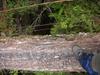
I did Logan's Ridge last Monday with a very inexperienced hiker and no rope to help him out, which is not a good idea. But we made it up ok. Is a great route up for all the rock scramblers, I really like it, but in saying that I have only done Logan's and South Ridge....so many more to do.
Here are some pics from the hike.
- Logans Ridge
- Logans Ridge
- View from the top
- Angry looking mountain
- Logans Ridge
-

Apophis - Nothofagus cunninghamii
- Posts: 1
- Joined: Fri 05 Oct, 2012 3:20 pm
- Location: Gold Coast, Queensland
- Region: Queensland
- Gender: Male
Re: Mount Barney routes
![]() by nq111 » Tue 09 Oct, 2012 6:20 pm
by nq111 » Tue 09 Oct, 2012 6:20 pm
Nice work!
If you like Logan's you will likely love eagles ridge the best on Barney. One part is sort of like that first photo for 300m straight up. So don't take the same mate by the sounds of it
Southeast ridge is great too - more so as a down route.
If you like Logan's you will likely love eagles ridge the best on Barney. One part is sort of like that first photo for 300m straight up. So don't take the same mate by the sounds of it
Southeast ridge is great too - more so as a down route.
-
nq111 - Phyllocladus aspleniifolius
- Posts: 932
- Joined: Mon 07 Mar, 2011 8:27 pm
- Region: Queensland
Re: Mount Barney routes
![]() by sef » Thu 18 Oct, 2012 4:57 pm
by sef » Thu 18 Oct, 2012 4:57 pm
Rocky Ck is scummy, wokket's advice above stands (although you could try finding a route out straight down the nose on the true right of the waterfall, well above the ledge -- I suspect one exists).
If you're going to protect your scrambling, please consider bringing back what you put in. There was a line of slings all the way up Short Leaning a while back, and I once souveneired 10m of boat rope off 'the tree' on Logan's. It's messy and of no use to following parties!
If you're going to protect your scrambling, please consider bringing back what you put in. There was a line of slings all the way up Short Leaning a while back, and I once souveneired 10m of boat rope off 'the tree' on Logan's. It's messy and of no use to following parties!
- sef
- Atherosperma moschatum

- Posts: 87
- Joined: Sun 20 Dec, 2009 8:07 pm
- Region: Queensland
Re: Mount Barney routes
![]() by findbuddha » Mon 26 Nov, 2012 6:58 pm
by findbuddha » Mon 26 Nov, 2012 6:58 pm
Can anyone compare the technical difficulty of South Ridge and South East Ridge with the track up Tibrogargan? Judging from a few pics I've seen in here there are some small sections of scrambling - would I be correct in thinking most of the challenge of these routes is to fitness rather than climbing as such?
I'm planning my first Barney trip with a few friends of slightly lesser confidence than myself and I want to make sure it's not above our abilities.
Thanks!
I'm planning my first Barney trip with a few friends of slightly lesser confidence than myself and I want to make sure it's not above our abilities.
Thanks!
- findbuddha
- Athrotaxis cupressoides
- Posts: 111
- Joined: Mon 26 Nov, 2012 5:33 pm
- Region: Queensland
Re: Mount Barney routes
![]() by Pteropus » Mon 26 Nov, 2012 9:32 pm
by Pteropus » Mon 26 Nov, 2012 9:32 pm
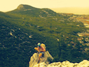
Hi findbuddha, welcome to the forum. I recently climbed the SE Ridge with two mates and went back down the South Ridge. A mate and I took some photos in the steepest sections of the SE Ridge, so I will post them to give you an idea of what is like exposure-wise.
As you can see it is not too bad. I have not been up any of the Glass House Mtns so cannot compare, but one of my mates who was on the walk said that he didn't feel as exposed on Barney SE Ridge as on Tibrogargan. Obviously that is second hand info so maybe better get it from someone first hand here. At no point did I feel the exposure was too bad though. There are no really exposed parts on the south-ridge, from what I remember and was pretty straight forward. I didn't bother to take pics on the way down though.
I hope that helps a little.
Cheers
Andrew
- Looking up the stepest section
- Rock scramble
- Thats me down there!
- Looking back down from the top of the SE Ridge
As you can see it is not too bad. I have not been up any of the Glass House Mtns so cannot compare, but one of my mates who was on the walk said that he didn't feel as exposed on Barney SE Ridge as on Tibrogargan. Obviously that is second hand info so maybe better get it from someone first hand here. At no point did I feel the exposure was too bad though. There are no really exposed parts on the south-ridge, from what I remember and was pretty straight forward. I didn't bother to take pics on the way down though.
I hope that helps a little.
Cheers
Andrew
- Pteropus
- Athrotaxis selaginoides
- Posts: 1045
- Joined: Sun 09 May, 2010 6:42 pm
- Location: Neither here nor there
- Region: Australia
- Gender: Male
Re: Mount Barney routes
![]() by ULWalkingPhil » Mon 26 Nov, 2012 10:10 pm
by ULWalkingPhil » Mon 26 Nov, 2012 10:10 pm
Wow, great images, really shows the terrain and what to expect.
-
ULWalkingPhil - Lagarostrobos franklinii

- Posts: 2269
- Joined: Wed 05 Jan, 2011 2:14 pm
- Region: Queensland
Re: Mount Barney routes
![]() by findbuddha » Tue 27 Nov, 2012 2:36 pm
by findbuddha » Tue 27 Nov, 2012 2:36 pm
Andrew, thanks heaps for the great pics and the description! Will be very helpful for us to make an informed decision.
- findbuddha
- Athrotaxis cupressoides
- Posts: 111
- Joined: Mon 26 Nov, 2012 5:33 pm
- Region: Queensland
Re: Mount Barney routes
![]() by findbuddha » Mon 18 Feb, 2013 1:47 pm
by findbuddha » Mon 18 Feb, 2013 1:47 pm
Well, just got back from a successful journey up SE and down South. Thanks to all who have shared info here
If anyone is coming up Barney Gorge in the near future and finds some black sunglasses my friend would love to know. We were about 20-30 metres downhill from the old hut site (slight 'detour' oops) when he slipped over and presumably lost them there.... Cheers!
If anyone is coming up Barney Gorge in the near future and finds some black sunglasses my friend would love to know. We were about 20-30 metres downhill from the old hut site (slight 'detour' oops) when he slipped over and presumably lost them there.... Cheers!
- findbuddha
- Athrotaxis cupressoides
- Posts: 111
- Joined: Mon 26 Nov, 2012 5:33 pm
- Region: Queensland
Re: Mount Barney routes
![]() by findbuddha » Sat 02 Mar, 2013 11:07 am
by findbuddha » Sat 02 Mar, 2013 11:07 am
Another Barney question.... the National Parks website (http://www.nprsr.qld.gov.au/parks/mount ... nd_weather) suggests the *average* minimum temp in winter is -4C - is this an accurate assessment?
I've never camped in weather that cold before and I imagine it could get even colder up at Rum Jungle etc. in July if there was a bit of wind around.
Cheers
I've never camped in weather that cold before and I imagine it could get even colder up at Rum Jungle etc. in July if there was a bit of wind around.
Cheers
- findbuddha
- Athrotaxis cupressoides
- Posts: 111
- Joined: Mon 26 Nov, 2012 5:33 pm
- Region: Queensland
Re: Mount Barney routes
![]() by Picaro » Sat 02 Mar, 2013 9:54 pm
by Picaro » Sat 02 Mar, 2013 9:54 pm
Just your average July day at lunchtime on the summit.
Even the rockface can be quite icy in the winter. I havent overnighted up there, but would say -4 is a good estimate.
Even the rockface can be quite icy in the winter. I havent overnighted up there, but would say -4 is a good estimate.
- Attachments
-
-

Picaro - Athrotaxis cupressoides
- Posts: 299
- Joined: Thu 25 Oct, 2012 5:35 am
- Location: Tamborine Mountain
- Region: Queensland
- Gender: Male
Re: Mount Barney routes
![]() by findbuddha » Sun 03 Mar, 2013 11:25 am
by findbuddha » Sun 03 Mar, 2013 11:25 am
Thanks! Looks chilly - think I might avoid overnighters there in winter until I'm a bit better prepared.
- findbuddha
- Athrotaxis cupressoides
- Posts: 111
- Joined: Mon 26 Nov, 2012 5:33 pm
- Region: Queensland
Re: Mount Barney routes
![]() by Art » Sun 14 Apr, 2013 12:43 am
by Art » Sun 14 Apr, 2013 12:43 am
Hi
I found this thread with a Google search and had to join.
Nice to see the color photos of the huts, I'd only seen a b&w one before.
it was an interesting experience to find pieces of it (or them),
I haven't seen bits of it in recent years, but for a few years in a row I found bits
of fiberglass (or fibro what you call it) and large nails at the Old Hut Site,
and it occurs to me that the people who demolished it threw it from Rum Jungle toward Egan Creek.
For those of you who are reading this, I wrote a GPS program over the last four years based
on Mt Barney National Park. It's iPhone version is not quite out yet at the time of posting this,
but is very close
http://www.freewebs.com/defxev/AVECios.htm
I don't want to promote the park at all. I have witnessed it's deterioration over a significant time,
and it saddens me to see how many cars can be packed into Yellowpinch car park now
So please allow me to promote it how I choose, and respect that I'd prefer it wasn't reposted.
Two levels of Government gave up some right to allow their map data to be given to you and me
for free within this App, and the App is free to the end user.
The following placeholder text describes Boogah-Boogah, a mountain with a name meaning
"Don't go there" or "Get Back", which was named by the Indigenous who also named a lot
of peaks of the aforementioned mountain.. Go figure! Gwyala, Bippoh, Barrabool, etc.
Cheers, Art.
- Art
- Nothofagus gunnii
- Posts: 32
- Joined: Sun 14 Apr, 2013 12:19 am
- Region: Queensland
Re: Mount Barney routes
![]() by findbuddha » Sun 14 Apr, 2013 8:34 pm
by findbuddha » Sun 14 Apr, 2013 8:34 pm
Any plans for an Android version? Cheers
- findbuddha
- Athrotaxis cupressoides
- Posts: 111
- Joined: Mon 26 Nov, 2012 5:33 pm
- Region: Queensland
Re: Mount Barney routes
![]() by Art » Mon 15 Apr, 2013 3:52 am
by Art » Mon 15 Apr, 2013 3:52 am
Hi,
Not any time soon unfortunately.
It's generally not time, as a programmer, to move to another platform while I'm still exploring my potential with the current one.
Not any time soon unfortunately.
It's generally not time, as a programmer, to move to another platform while I'm still exploring my potential with the current one.
- Art
- Nothofagus gunnii
- Posts: 32
- Joined: Sun 14 Apr, 2013 12:19 am
- Region: Queensland
Re: Mount Barney routes
![]() by sef » Thu 18 Apr, 2013 6:18 pm
by sef » Thu 18 Apr, 2013 6:18 pm
I can recommend the OpenCycleMap dataset for general purpose stuff in SEQ. "Backcountry Navigator" works well for Android.
- screenshot_2012-10-14_0025.png (292.61 KiB) Viewed 54441 times
- sef
- Atherosperma moschatum
- Posts: 87
- Joined: Sun 20 Dec, 2009 8:07 pm
- Region: Queensland
Re: Mount Barney routes
![]() by findbuddha » Sat 20 Apr, 2013 11:03 pm
by findbuddha » Sat 20 Apr, 2013 11:03 pm
Thanks sef and Art
I'm already using the OpenCycleMap data set actually... looks like the map data Art has used has higher detail level though. I wonder if the Qld gov. would be willing to sell digital map data.
I've been using AlpineQuest on Android - I highly recommend it!
Cheers
I'm already using the OpenCycleMap data set actually... looks like the map data Art has used has higher detail level though. I wonder if the Qld gov. would be willing to sell digital map data.
I've been using AlpineQuest on Android - I highly recommend it!
Cheers
- findbuddha
- Athrotaxis cupressoides
- Posts: 111
- Joined: Mon 26 Nov, 2012 5:33 pm
- Region: Queensland
Who is online
Users browsing this forum: No registered users and 10 guests