Forum rules
Queensland specific bushwalking discussion. Please avoid publishing details of access to sensitive areas with no tracks.Mt Razorback & the Lost World
Sat 15 Oct, 2011 3:41 pm
I know the subject line sounds ominous.....and for good reason 
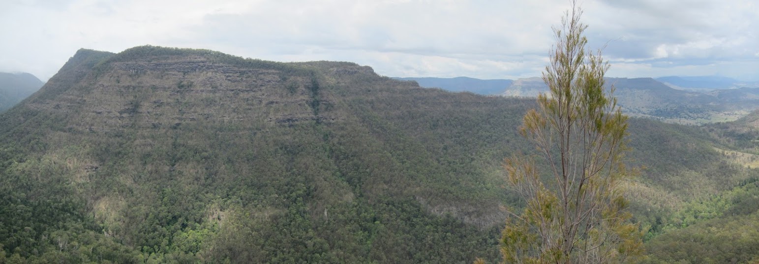
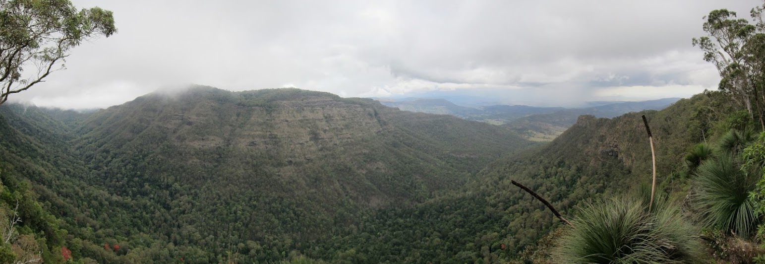
After downloading a GPS file from Wikiloc, a friend & I recently embarked on an overnight circuit taking in the peak of Mt Razorback. With an 18kg pack, the first leg to get to the ridge line, is a real heart starter...and the subsequent traversing of the ridge, a real heart stopper!!! To give you an idea of the ridge line, the narrowest section is blocked by a 700mm wide boulder (see photo) which you need to go around or over. Neither of these options would be palatable to a sane person. Thankfully the majority of the ridge gave you the option of not being so close to a certain-death fall (see photos).
The plateau of Mt Razorback is a verdant rainforest which is spectacular. Due to the density of the forest, no real views are possible of the surrounding valleys & ranges.
The GPS had some ‘issues’ (that is accuracy issues) as we were making our exit off the south-east of the plateau. We were too far south and missed the start of the ridge which meant the descent got significantly steep (note: after downloading my GPS files later, I now know we were heading for a cliff). Lucky for us the GPS regained its composure (& accuracy) and we backpedalled to a more decent descent. We then discovered Mt Razorback was named for its pair of razorback thin ridges. Yep, it was back to heart-in-mouth knife-edge trekking. We were treated to many great specimens of orchids and epiphytes, and the views were pretty breathtaking.
We dismounted the ridge at the saddle (between Mt Razorback & Mt Worendo) and made our way down to Albert River (right branch). Energy levels were waning after the morning efforts but we still had 4 hrs of rock hopping (see photo) before getting to the edge of the National Park. The things we do for ‘fun’
We won’t be rushing back to Mt Razorback in the near future but we felt it was a good accomplishment and we saw some great country with the natural beauty of Lost World.
Aside: my GPS registered the trip as ~20km. My advice is:- you need to have a good level of fitness; be confident and comfortable with heights; have some scrambling skills; be prepared for GPS accuracy being variable and do the circuit in a clockwise direction.
- Attachments
-
- photo from "Hiking in S.E. Queensland"
- difficult part of ridge.jpg (47.98 KiB) Viewed 37000 times
-
- Albert River.jpg (133.81 KiB) Viewed 37000 times
-
- easy part of ridge 2.jpg (132.82 KiB) Viewed 37000 times
-
- easy part of ridge.jpg (143.29 KiB) Viewed 37000 times
-
- Razorback Mountain peak.jpg (139.18 KiB) Viewed 37000 times
Re: Mt Razorback & the Lost World
Sat 22 Oct, 2011 10:41 pm
Nice one Shardie. That's one of the best off track walks in Lamington if you ask me.
We were in the area around the same time as well. You didn't drive a white stationwagon or lose a pair of sunglasses did you?
We did the the traverse from the western razorback to the eastern saddle and return in a day. I would usually prefer to make a circuit of it as well but the thought of the rockhop back to the cars didn't appeal. Where did you camp ? I'd also never heard of wikiloc before either (I'm not really a gps user) so thanks for bringing it to my attention.
Re: Mt Razorback & the Lost World
Sun 23 Oct, 2011 7:31 am
yes that was us with the stn wagon & yes my friend did lose his glasses. We camped at the peak of Mt Razorback (near the cairn itself). we set up camp ~4:30pm. Even though the rock hopping wasn't enjoyable, I wouldn't look forward to scrambling back down the western ridge. The path we took up had some sections which would have been difficult to travel down.
Wikiloc & Everytrail (& a bit of Peakware) are the sites I use to get GPS files or share my travels.
Wikiloc & Everytrail (& a bit of Peakware) are the sites I use to get GPS files or share my travels.
Re: Mt Razorback & the Lost World
Mon 24 Oct, 2011 8:18 am
Ah - the memories! That was one of our better walks back in the day and I recall a grim climb with packs up the steep flank of Mt. Razorback with ticks raining upon us as we clawed through thick underbrush. We also enjoyed the special rainforest then dropped down from the saddle before Mt. Worendo to a rudimentary rocky campsite in a field of polished river stones on the banks of the Albert River. Warning - do not use river stones in your campfire! That night was especially eerie under blustery winds that wafted squadrons of fireflies past our tent like lost spirits guarding this remote place. Next morning we enjoyed lots of athletic boulder hopping that became a special challenge under our improvised rule to never break stride. Those were the days…..
Re: Mt Razorback & the Lost World
Mon 24 Oct, 2011 9:41 am
River stones, I believe they can explode in a fire,
That's one scary walk, particularly with a fully laden pack on.
That's one scary walk, particularly with a fully laden pack on.
Re: Mt Razorback & the Lost World
Tue 20 Dec, 2011 5:58 pm
can anyone tell me how to get to the western end of this walk ? i have tried getting to mt razor back from mt worendo a few years ago but had to turn back because there was no obvious track to follow and i was running out of time.
Re: Mt Razorback & the Lost World
Thu 22 Dec, 2011 9:18 am
tallevalley28 wrote:can anyone tell me how to get to the western end of this walk ? i have tried getting to mt razor back from mt worendo a few years ago but had to turn back because there was no obvious track to follow and i was running out of time.
At what point did you turn around? The track from Echo Point to Mt. Worrendo is fairly easy to follow. Although the track doesn't hit the actual peak which you have to find by heading up off the track for 20m or so I think. From there we found a very vague track with some pink ribbons but this dissapeared after a while. Once you get your bearings and head off in the right direction from the peak it was reasonably easy to follow the terrain once you were established on the correct ridge. Making sure not to deviate too far down to the right. It took us probably 7 hours with overnight packs to get to the saddle campsite. I imagine I could cut at least an hour off this doing it a second time and with lighter packs.
Re: Mt Razorback & the Lost World
Sat 07 Jan, 2012 10:46 am
Here are a few slide scans from the the early 1970's of one of my many walks to Lost World.
- On top of Lost World ridge at northern end looking NW over the valley of the Albert River Right Branch.
- Approaching the start of the razorback ridge with the Lost World in the background.
Re: Mt Razorback & the Lost World
Sat 07 Jan, 2012 10:56 am
. . . and a couple more from the same trip.
- Ascending the very steep grass slopes between the cliff lines below Lost World.
- Near the top of the grass slope ascent is this memorial plaque to Heather Easton who fell from this point on 10th December 1974.
Re: Mt Razorback & the Lost World
Sat 07 Jan, 2012 7:38 pm
Great pics tas-man & touching plaque.....
Re: Mt Razorback & the Lost World
Mon 10 Dec, 2012 12:05 pm
Some pics of Lost World I took from Castle Crag last week.
Re: Mt Razorback & the Lost World
Mon 10 Dec, 2012 4:20 pm
Nice! I love that the flame trees are flowering in the valley.
Re: Mt Razorback & the Lost World
Thu 13 Dec, 2012 7:27 am
shardie wrote:After downloading a GPS file from Wikiloc, a friend & I recently embarked on an overnight circuit taking in the peak of Mt Razorback.
Hi,
I have came across your wikiloc entry and it states a distance of 8.04 miles (12.93km). How many hours were required to complete that distance? Are there any visible tracks in that cir. or is it just pure bush bashing?
Cheers.
Re: Mt Razorback & the Lost World
Thu 13 Dec, 2012 9:26 am
gbagua wrote:shardie wrote:After downloading a GPS file from Wikiloc, a friend & I recently embarked on an overnight circuit taking in the peak of Mt Razorback.
Hi,
I have came across your wikiloc entry and it states a distance of 8.04 miles (12.93km). How many hours were required to complete that distance? Are there any visible tracks in that cir. or is it just pure bush bashing?
Cheers.
Route finding and travel on the ridges is fairly unhindered, it's more about being careful and how steep it is. On top of Lost World the rainforest is very thick. If you stick to the Northern escarpment it isn't as thick. Can't comment on the path down from the saddle and back along the creek.
Re: Mt Razorback & the Lost World
Thu 20 Dec, 2012 1:44 am
sorry for the delay :S
As Cam mentioned, there is no track as such. The ridge walking is pretty obvious...the top of Mt Razorback has thick vegetation & we were pretty much following the downloaded track. As to when to dismount the saddle....we just picked a spot that looked do-able.
I have my GPS files I can share with you if you want to PM me.
cheers,
Shawn
Re: Mt Razorback & the Lost World
Thu 20 Dec, 2012 12:38 pm
Thanks. PM sent. 
Re: Mt Razorback & the Lost World
Thu 20 Dec, 2012 6:36 pm
It's been a while since I did this route, same as Shawn's,
http://en.wikiloc.com/wikiloc/view.do?id=2125638
but I remember that &!@$! creek well.
That stretch down the Albert River is slow going seemingly endless boulder hopping ankle breaking (if you're not careful) especially as about the last 2 hours in the river was headlamps in the pitch dark.
Total Shawn's times up and they come to 11 hours for 19.7km (above wikiloc has 12.23 miles). Be warned, make it two days and camp in the saddle, or if you really must do it in one day start v. early and make sure you pack a headlamp with fresh batteries.
Re: Mt Razorback & the Lost World
Sun 10 Feb, 2013 6:36 pm
I had a great view of Lamington when flying into Brisbane in January and managed to snap some photos . Here's two that show the Lost World, Castle Crag and O'Reilly's.
Re: Mt Razorback & the Lost World
Tue 30 Jul, 2013 1:42 pm
Feckity feck, I'd forgotten how narrow that razorback really is. I went up there with my Dad, sister and one of her friends 15 years ago - I'd say we scarred the friend for life but she's a skydiving instructor now. Maybe she feels safer with a parachute on!
Planning to take another friend up there, as soon as we get a rain, wedding and birthday-free weekend. Now to decide whether to try to do the circuit, or a return walk...
Planning to take another friend up there, as soon as we get a rain, wedding and birthday-free weekend. Now to decide whether to try to do the circuit, or a return walk...
Re: Mt Razorback & the Lost World
Mon 03 Apr, 2017 2:00 pm
I am intending to try this again later this month. I climbed Mt Razorback in 1979, then again in 1982. Do not remember having any difficulties back then finding our way up to the western ridge. Went back for a third time at the end of last year and had trouble finding the way up to the ridge. Can anyone give me clear directions from Kerry Road to the western ridge? The way I went in December was very steep and slippery. Nothing like all this years ago.
Cheers
Don
Cheers
Don
Re: Mt Razorback & the Lost World
Mon 03 Apr, 2017 6:53 pm
Before finding a way, something else to consider: to get to the western ridge easily from the Kerry road you have to cross private property and I don't know if access permission is currently available - the situation has changed over the years. Finding out who to ask might take some effort - try talking to a Lamington ranger. If you get permission the same people might show you the best route to the ridge.
© Bushwalk Australia and contributors 2007-2013.