Any suggestions please?
I have two nights out at the Grampians...but...
-->Arriving late Friday night and pitch tent.
--> Leaving early on Sunday morning (by around 9).
This gives two options:
A. easy option --- camp in the same spot Friday Night and Saturday night, and just do a big day hike on Saturday, preferably a long scenic loop.
B. more adventurous option --- set up camp Friday night, hike Satuday and camp out in a different spot, then hike back to the car Sunday morning and leave. So long as it is only a couple of hours walking on Sunday morning, should be OK to leave in time.
I have done Mount Difficult before. I would like to check out another section maybe Southern or Western. Major Mitchell Plateau looks good. Into nice scenery, of course, and camping under the stars, of course. Not scared of a long day hike on Saturday.
Are there any recommednations for me for either option A or B?
Cheers! Cal
Grampians loop day/o'night hike...what would you do?
Forum rules
Victoria specific bushwalking discussion. Please avoid publishing details of access to sensitive areas with no tracks.
Victoria specific bushwalking discussion. Please avoid publishing details of access to sensitive areas with no tracks.
16 posts
• Page 1 of 1
Grampians loop day/o'night hike...what would you do?
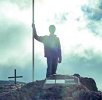
![]() by cal_blam » Wed 24 Sep, 2014 12:17 pm
by cal_blam » Wed 24 Sep, 2014 12:17 pm
- cal_blam
- Nothofagus gunnii

- Posts: 16
- Joined: Sun 01 Aug, 2010 3:31 pm
- Region: Victoria
- Gender: Male
Re: Grampians loop day/o'night hike...what would you do?
![]() by icefest » Wed 24 Sep, 2014 12:32 pm
by icefest » Wed 24 Sep, 2014 12:32 pm
Mitchell plateau should be a good walk. You can camp at the southern end, walk north, and then either camp at the camp just to the north of the summit, or in the saddle between the two peaks.
The former has the better view, and the latter the less walking the next day.
You'll need to hitch back to the car.
The former has the better view, and the latter the less walking the next day.
You'll need to hitch back to the car.
Men wanted for hazardous journey. Low wages, bitter cold, long hours of complete darkness. Safe return doubtful.
-
icefest - Lagarostrobos franklinii

- Posts: 4479
- Joined: Fri 27 May, 2011 11:19 pm
- Location: www.canyoninginvictoria.org
- Region: Victoria
Re: Grampians loop day/o'night hike...what would you do?
![]() by Snowzone » Wed 24 Sep, 2014 12:35 pm
by Snowzone » Wed 24 Sep, 2014 12:35 pm
Hi Cal, not having much time on the Sunday makes it hard for a walk in camp. I'd be more inclined to do a nice big day walk on the Saturday.
You would not have time to walk out from Major Mitchell Plateau Sunday morning but you could walk from Mount William carpark to the plateau and back as a day walk.
On the Western side you can walk into the Fortress and back out in a day.
There's also plenty of other good daywalks in the Gramps. A lot of the Northern Gramps is still closed due to the last lot of fires.
-
Snowzone - Phyllocladus aspleniifolius

- Posts: 533
- Joined: Sat 11 Dec, 2010 12:10 pm
- Region: Victoria
- Gender: Female
Re: Grampians loop day/o'night hike...what would you do?
![]() by Isis » Wed 24 Sep, 2014 6:14 pm
by Isis » Wed 24 Sep, 2014 6:14 pm
Your not going get back by 9am Sunday if you walk the Major Mitchell Plateau.
- Isis
- Nothofagus gunnii
- Posts: 33
- Joined: Sun 15 Jul, 2012 9:16 am
- Region: Victoria
Re: Grampians loop day/o'night hike...what would you do?
![]() by icefest » Wed 24 Sep, 2014 6:46 pm
by icefest » Wed 24 Sep, 2014 6:46 pm
It depends on how you do the hike. The full 40km is a long, very difficult daywalk, but if you only walk the ridgeline it will only around 23km, which is not an easy walk, but doable.
I'm not sure as to how much you are able to walk (and how comfortable you are with long days).
Within your constraints, this is what I would do:
Friday Night:
---Drive to Jimmy Creek Campground, set up tent and stay the night
Saturday:
---Get up early, almost at sunrise, and hitch up to the Mt William carpark. Aim to be at the carpark before 9 am.
---Walk the 23km back to Jimmy Creek campground that day.
---Camp at the same campsite.
Sunday
---Pack up and leave.
Walking downhill is easier than uphill, but you should consider driving up Mt William to watch the sunrise and then hitching back to Jimmy creek. You will then have to walk in the opposite direction. This has greater chances of being on time (it's easier to ask for a ride) and will enable you to see the sunrise and sunset. It will be a much harder walk.
Whatever you do, take a good light and a GPS in case you get lost.
Lastly, this is what I would do myself. It's a long day and can be impossible if you have a heavy pack and/or are unfit. Don't do it if you are unsure.
Men wanted for hazardous journey. Low wages, bitter cold, long hours of complete darkness. Safe return doubtful.
-
icefest - Lagarostrobos franklinii
- Posts: 4479
- Joined: Fri 27 May, 2011 11:19 pm
- Location: www.canyoninginvictoria.org
- Region: Victoria
Re: Grampians loop day/o'night hike...what would you do?
![]() by Lophophaps » Thu 25 Sep, 2014 9:23 am
by Lophophaps » Thu 25 Sep, 2014 9:23 am
Given the 9 am Sunday departure, a pack carrying walk is not viable.
There's some good off-track walking behind Rosea. On the Friday, drive to the Rosea camping area, then west on, I think, the Stoney Creek Road. (I do not have a map with me at present.) After a few minutes there's a T intersection, probably the Rosea Track. Go south (left) down this for about ten minutes to a small campsite on the creek. There are other campsites nearby, but they are hard to describe. From the creek you can walk to the waterfall, Eastern Wall, Tower Hill, Rosea, Bundaleer and other places. The distances are not great and the terrain is slow, but the scenery is brilliant and it's relatively isolated.
Parks Victoria seem to say that this area is open. See
http://parkweb.vic.gov.au/__data/assets ... Update.pdf
http://parkweb.vic.gov.au/__data/assets ... Report.pdf
for information about walking tracks and roads.
-
Lophophaps - Auctorita modica

- Posts: 3382
- Joined: Wed 09 Nov, 2011 9:45 am
- Region: Victoria
- Gender: Male
Re: Grampians loop day/o'night hike...what would you do?
![]() by peregrinator » Thu 25 Sep, 2014 5:35 pm
by peregrinator » Thu 25 Sep, 2014 5:35 pm
Lophophaps wrote:There's some good off-track walking behind Rosea. On the Friday, drive to the Rosea camping area, then west on, I think, the Stoney Creek Road. (I do not have a map with me at present.) After a few minutes there's a T intersection, probably the Rosea Track. Go south (left) down this for about ten minutes to a small campsite on the creek. There are other campsites nearby, but they are hard to describe. From the creek you can walk to the waterfall, Eastern Wall, Tower Hill, Rosea, Bundaleer and other places. The distances are not great and the terrain is slow, but the scenery is brilliant and it's relatively isolated.
Great suggestion, Lophophaps. You are correct about the names of both tracks. And about the scenery. From Rosea Track, Calectasia Falls (would be the one you mean) is close by to the west and Castle Rock to the south. All should be achievable in a day, including Mt Rosea.
- peregrinator
- Athrotaxis selaginoides

- Posts: 1780
- Joined: Fri 15 Apr, 2011 2:50 pm
- Region: Victoria
Re: Grampians loop day/o'night hike...what would you do?
![]() by cal_blam » Wed 01 Oct, 2014 3:36 pm
by cal_blam » Wed 01 Oct, 2014 3:36 pm
Think we will leave the camp set up this time around and do a big day walk...so Rosea suits well!
Thanks everyone for the great ideas!
Thanks everyone for the great ideas!
- cal_blam
- Nothofagus gunnii
- Posts: 16
- Joined: Sun 01 Aug, 2010 3:31 pm
- Region: Victoria
- Gender: Male
Re: Grampians loop day/o'night hike...what would you do?
![]() by cal_blam » Wed 01 Oct, 2014 4:11 pm
by cal_blam » Wed 01 Oct, 2014 4:11 pm
Lophophaps wrote:Given the 9 am Sunday departure, a pack carrying walk is not viable.
There's some good off-track walking behind Rosea. On the Friday, drive to the Rosea camping area, then west on, I think, the Stoney Creek Road. (I do not have a map with me at present.) After a few minutes there's a T intersection, probably the Rosea Track. Go south (left) down this for about ten minutes to a small campsite on the creek. There are other campsites nearby, but they are hard to describe. From the creek you can walk to the waterfall, Eastern Wall, Tower Hill, Rosea, Bundaleer and other places. The distances are not great and the terrain is slow, but the scenery is brilliant and it's relatively isolated.
Parks Victoria seem to say that this area is open. See
http://parkweb.vic.gov.au/__data/assets ... Update.pdf
http://parkweb.vic.gov.au/__data/assets ... Report.pdf
for information about walking tracks and roads.
Uh oh...rosea track is closed and I am in a 2wd. Is there a good place I can launch off for a good rosea day hike from a more accessible campsite, but still somewhere nice and picturesque? Cheers.
- cal_blam
- Nothofagus gunnii
- Posts: 16
- Joined: Sun 01 Aug, 2010 3:31 pm
- Region: Victoria
- Gender: Male
Re: Grampians loop day/o'night hike...what would you do?
![]() by peregrinator » Wed 01 Oct, 2014 5:34 pm
by peregrinator » Wed 01 Oct, 2014 5:34 pm
cal_blam wrote:Uh oh...rosea track is closed and I am in a 2wd. Is there a good place I can launch off for a good rosea day hike from a more accessible campsite, but still somewhere nice and picturesque? Cheers.
If you're referring to http://parkweb.vic.gov.au/__data/assets/pdf_file/0007/628936/Map6.pdf, that is showing tracks currently closed to vehicles. You can use the track for walking. See http://parkweb.vic.gov.au/__data/assets/pdf_file/0003/621246/Grampians-National-Park-Update.pdf
In fact, the best time to walk many tracks in the state is precisely when seasonal closures are in place. Quite a lot of them should be closed to vehicles all year, but that's another story.
- peregrinator
- Athrotaxis selaginoides
- Posts: 1780
- Joined: Fri 15 Apr, 2011 2:50 pm
- Region: Victoria
Re: Grampians loop day/o'night hike...what would you do?
![]() by cal_blam » Thu 02 Oct, 2014 1:48 pm
by cal_blam » Thu 02 Oct, 2014 1:48 pm
peregrinator wrote:
If you're referring to http://parkweb.vic.gov.au/__data/assets/pdf_file/0007/628936/Map6.pdf, that is showing tracks currently closed to vehicles. You can use the track for walking. See http://parkweb.vic.gov.au/__data/assets/pdf_file/0003/621246/Grampians-National-Park-Update.pdf
In fact, the best time to walk many tracks in the state is precisely when seasonal closures are in place. Quite a lot of them should be closed to vehicles all year, but that's another story.
Still a bit confused though about where the campsites are that are accesible by car. I found this:
Mt Rosea Loop
Start: Rosea Campground, Silverband
From Rosea Campground cross Stony Creek Road for a climb through messmate forest to the plateau. Follow markers through sandstone outcrops, Eagle Rock and cross bridge over the Gate of the East Wind. Continue the ascent up terraces to the intersection, turning left to the summit. View is one of the most spectacular in the Park. Returning to the intersection veer left and continue until it widens into an old 4WD track. Follow this to Burma Track and continue along Burma track to reach Silverband Road. Turn right down the road for 200m and take the Delley's Dell walking track through Soft Tree Ferns to the Silverband Road and back to the campground.
http://www.grampiansnationalpark.com/gr ... /walks.asp
I think will do this loop - so will be setting up at Rosea Campground. It's not on the PV map but I guess will find it if driving down the Silverband Road? Might be the best strategy arriving by night.
Is it OK to also access the creek, waterfall, Eastern Wall, Tower Hill from that campground by foot?
Might be best if I go invest in a Gramps NP map this arvo
- cal_blam
- Nothofagus gunnii
- Posts: 16
- Joined: Sun 01 Aug, 2010 3:31 pm
- Region: Victoria
- Gender: Male
Re: Grampians loop day/o'night hike...what would you do?
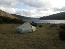
![]() by cal_blam » Mon 06 Oct, 2014 10:17 am
by cal_blam » Mon 06 Oct, 2014 10:17 am
OP update for future hikers:
hike:
Please note there is no longer a "loop" track option for Rosea carpark to top of Mt Rosea and return.
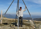
We ended up doing sundial carpark -> Rosea carpark -> top of Mt Rosea and back the same way. It was a lovely scenic walk. Not difficult in any part, but tired by the end with a day pack.With about an hour up top for lunch and nap overlooking the wonderful views, we spent about six hours out.
Well signposted.
camp:
Apparently Rosea campground is bush camping/no toilets.
Instead we chose Plantation campground for Fri/Sat nights and drove to our hike start in morning. Still free for now. Easy to find at night not knowing area.
Toilets and (untreated water) taps and fireplaces. 10km north of Halls Gap up Mt zero unsealed 2wd road. Take care for wildlife especially driving at dusk.
From Melbourne makes a great weekend if you have limited time but still want to do a nice walk and camp a couple of nights.
hike:
Please note there is no longer a "loop" track option for Rosea carpark to top of Mt Rosea and return.
We ended up doing sundial carpark -> Rosea carpark -> top of Mt Rosea and back the same way. It was a lovely scenic walk. Not difficult in any part, but tired by the end with a day pack.With about an hour up top for lunch and nap overlooking the wonderful views, we spent about six hours out.
Well signposted.
camp:
Apparently Rosea campground is bush camping/no toilets.
Instead we chose Plantation campground for Fri/Sat nights and drove to our hike start in morning. Still free for now. Easy to find at night not knowing area.
Toilets and (untreated water) taps and fireplaces. 10km north of Halls Gap up Mt zero unsealed 2wd road. Take care for wildlife especially driving at dusk.
From Melbourne makes a great weekend if you have limited time but still want to do a nice walk and camp a couple of nights.
- cal_blam
- Nothofagus gunnii
- Posts: 16
- Joined: Sun 01 Aug, 2010 3:31 pm
- Region: Victoria
- Gender: Male
Re: Grampians loop day/o'night hike...what would you do?
![]() by Strider » Mon 06 Oct, 2014 10:19 am
by Strider » Mon 06 Oct, 2014 10:19 am
Looks like a great walk. How long is the drive from Melbourne?
-
Strider - Lagarostrobos franklinii
- Posts: 6030
- Joined: Mon 07 Nov, 2011 6:55 pm
- Location: Point Cook
- Region: Victoria
- Gender: Male
Re: Grampians loop day/o'night hike...what would you do?
![]() by neilmny » Mon 06 Oct, 2014 12:08 pm
by neilmny » Mon 06 Oct, 2014 12:08 pm
Maybe 3 hours from your location Strider. It's about 3 1/2 or so from the outer east side.
Probably Western Ringroad, Western freeway out past Ballarat to Ararat then to Halls Gap (C222)
via Moyston and Pomonal.
Probably Western Ringroad, Western freeway out past Ballarat to Ararat then to Halls Gap (C222)
via Moyston and Pomonal.
-
neilmny - Lagarostrobos franklinii
- Posts: 2604
- Joined: Fri 03 Aug, 2012 11:19 am
- Region: Victoria
- Gender: Male
Re: Grampians loop day/o'night hike...what would you do?
![]() by Snowzone » Mon 06 Oct, 2014 8:36 pm
by Snowzone » Mon 06 Oct, 2014 8:36 pm
cal_blam wrote:OP update for future hikers:
hike:
Please note there is no longer a "loop" track option for Rosea carpark to top of Mt Rosea and return.
We ended up doing sundial carpark -> Rosea carpark -> top of Mt Rosea and back the same way. It was a lovely scenic walk. Not difficult in any part, but tired by the end with a day pack.With about an hour up top for lunch and nap overlooking the wonderful views, we spent about six hours out.
Well signposted.
camp:
Apparently Rosea campground is bush camping/no toilets.
Instead we chose Plantation campground for Fri/Sat nights and drove to our hike start in morning. Still free for now. Easy to find at night not knowing area.
Toilets and (untreated water) taps and fireplaces. 10km north of Halls Gap up Mt zero unsealed 2wd road. Take care for wildlife especially driving at dusk.
From Melbourne makes a great weekend if you have limited time but still want to do a nice walk and camp a couple of nights.
The loop you have mentioned is most certainly still able to be done. It starts at the old Rosea campground and finishes where Burma track comes back out onto Silverband Road. Then you have a short section of road to walk back on.
Rosea Campground was closed a few years back. The road in that accesses Calectasia Falls and Castle Rock is seasonal, I think, its been a long time since I've seen that track open now that I think about it.
-
Snowzone - Phyllocladus aspleniifolius
- Posts: 533
- Joined: Sat 11 Dec, 2010 12:10 pm
- Region: Victoria
- Gender: Female
Re: Grampians loop day/o'night hike...what would you do?
![]() by peregrinator » Thu 20 Nov, 2014 11:20 am
by peregrinator » Thu 20 Nov, 2014 11:20 am
I was in the area recently, so here is an update.
The gate on Rosea Track near the pad to Tower Hill is closed to walkers and vehicles due to the area being used for the reintroduction of Brush-tailed Rock Wallabies. So that means there's no access to Castle Rock and et cetera. Unless you're one of them 4WD hoons wot drives round gates.
The pad which continued east from Tower Hill to Calectasia Falls (well, it did when I was there in 2005) is overgrown so a compass is required.
There was also a locked gate on what I think is the track from Delleys Dell to the Silverband Road near the discontinued Rosea campground. Not sure about this as it's not an area I've previously walked. But the track from the Rosea camp to Sundial has been remade, passing a Keep Out -- Construction Zone sign where the old track commenced some switchbacks.
- peregrinator
- Athrotaxis selaginoides
- Posts: 1780
- Joined: Fri 15 Apr, 2011 2:50 pm
- Region: Victoria
16 posts
• Page 1 of 1
Who is online
Users browsing this forum: No registered users and 15 guests