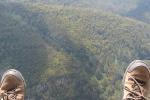
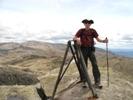
Half day return walk from Big Bend, Mt Wellington.
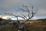
Collins Bonnet is located amongst numerous peaks North West of the Mt Wellington pinnacle, Wellington Park. A leisurely half day walk with spectacular views over Hobart, the northern and eastern suburbs, the Channel region, the Huon valley, North towards Collinsvale and New Norfolk and West towards the South West world heritage area. Tasmap: Wellington Park Recreation Map 1:20000.
The route given here takes the walker over Mt Connection and the track consists of fire trail, single walking track, duck board and a little boulder hopping on the North side of Mt Connection and the final approach to Collins Bonnet.
I can recommend this route to anyone from beginners and children to seasoned bush walkers looking for a half day stroll.
Due to the possibility of fast changing weather conditions in this region be sure to pack some warm clothes.
Approx distance: 14km return.
Allow 4 - 5 hours to complete the journey and return.
Map, photos, (rough) gpx, description, elevation profile, etc. available here:
http://www.sharemyroutes.com/routes/Aus ... tails.aspx
Collins Bonnet [Map & Photos]
Forum rules
Tasmania specific bushwalking discussion. Please avoid publishing details of access to sensitive areas with no tracks.
Tasmania specific bushwalking discussion. Please avoid publishing details of access to sensitive areas with no tracks.
3 posts
• Page 1 of 1
Collins Bonnet [Map & Photos]
![]() by ben.h » Wed 06 Feb, 2008 7:46 pm
by ben.h » Wed 06 Feb, 2008 7:46 pm
-
ben.h - Athrotaxis cupressoides

- Posts: 138
- Joined: Wed 23 Jan, 2008 6:00 pm
- Location: Hobart
Re: Collins Bonnet [Map & Photos]
![]() by tasadam » Thu 07 Feb, 2008 7:10 am
by tasadam » Thu 07 Feb, 2008 7:10 am
Another excellent post by our friend ben.h in Hobart.
Thanks!
Thanks!
-
tasadam - Magnus administratio

- Posts: 5940
- Joined: Tue 10 Apr, 2007 6:58 pm
- Location: Near Devonport, Tasmania
- ASSOCIATED ORGANISATIONS: TasmaniART, Smitten Merino, Macpac
- Region: Tasmania
- Gender: Male
Re: Collins Bonnet [Map & Photos]
![]() by johnw » Thu 07 Feb, 2008 8:24 am
by johnw » Thu 07 Feb, 2008 8:24 am
[quote="ben.h"]Half day return walk from Big Bend, Mt Wellington.
Nice post and pics Ben. Have been to Collins Bonnet once but we came via Myrtle Forest near Collinsvale. Fairly solid climb up via the left branch in the forest. Almost got blown off the top of Collins Bonnet. We had planned to do the circuit of Collins Bonnet, Trestle Mtn, Collins Cap (Chapman Day Walks). Unfortunately the weather turned foul on the way to Trestle Mtn so we headed for Collins Cap. By then it was raining heavily, so gave it a miss as well and headed back down through the forest.
johnw
John W
In Nature's keeping they are safe, but through the agency of man destruction is making rapid progress - John Muir c1912
In Nature's keeping they are safe, but through the agency of man destruction is making rapid progress - John Muir c1912
-
johnw - Lagarostrobos franklinii

- Posts: 9026
- Joined: Wed 23 Jan, 2008 11:59 am
- Location: Macarthur Region - SW Sydney
- Region: New South Wales
- Gender: Male
3 posts
• Page 1 of 1
Who is online
Users browsing this forum: No registered users and 23 guests