Adamsons Peak
Forum rules
Tasmania specific bushwalking discussion. Please avoid publishing details of access to sensitive areas with no tracks.
Tasmania specific bushwalking discussion. Please avoid publishing details of access to sensitive areas with no tracks.
3 posts
• Page 1 of 1
Adamsons Peak
![]() by Allan » Sun 03 Feb, 2008 11:54 am
by Allan » Sun 03 Feb, 2008 11:54 am
Recently climbed Adamson's Peak. Walk starts after a 14k drive in from Strathblane, which is just south of Dover.A very steep climb up to the plateau and a collapsed hut. Track is quite clear to this point, but becomes a bit vague from here on, but as the summit is in sight, this is not a problem.Found the decent harder than the climb up, as always. Track is quite wet in places and after heavy rain could be a bit difficult.Took 5 1/2 hrs, but the general would appear to be about 7 1/2 hrs, also a bit more realistic as we hammered it a bit. This is a very good day walk, with great views from the summit.
- Allan
- Nothofagus cunninghamii

- Posts: 1
- Joined: Sun 03 Feb, 2008 11:17 am
Re: Adamsons Peak
![]() by leebel » Sun 03 Feb, 2008 1:25 pm
by leebel » Sun 03 Feb, 2008 1:25 pm
I did the walk on 30/1/2008 with two friends (we are all over 55). It was a perfect day. Considering it was the driest January on record (120 years), we found the plateau very nice walking. Bit scrubby just before the first peak. The peak would be very exposed in anything but good weather. Found the climb easier than the decent (which seemed to go on forever). We left at ~10am and returned to the car around 5pm. Warning: we saw two tiger snakes at the ruins and one was over 2m long. So - keep your eyes open as it is nearing mating season (in mid-February they get quite aggressive). Good news, I got mobile coverage from the ruins. The view from the top is awesome on a clear day. You can see most of the peaks in S.Tas, Bruny Island, Southport Lagoon etc. Can't say I'd rush to do it again though as it is rather up then down again.
- leebel
- Nothofagus cunninghamii
- Posts: 3
- Joined: Sun 03 Feb, 2008 1:13 pm
Re: Adamsons Peak
![]() by bluewombat » Thu 14 Feb, 2008 4:19 pm
by bluewombat » Thu 14 Feb, 2008 4:19 pm
I walked up this one on Regatta day just gone. Distant sound of logging operations was a bit off-putting for the first hour but nice after that. Lots of cool fungi after the recent rain and no tiger snakes to be seen. Peak was in cloud most of the time so views not perfect. 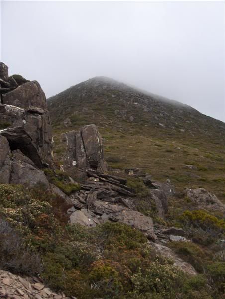
For those interested in doing it, it is worth noting you can no longer access Peak Rivulet road from either Creekton or Adamsons road. Take the Esperance road turn off (at the point the Hwy crosses the Esperance river) and follow the "Forest Tour" signs onto Peak Rivulet road. The track head is well marked along this road. You can also get onto Peak Rivulet road via the Old Hastings road turn off (to Duckhole Lake amongst other places) which is several kms past Strathblane. I would be keen to hear what people know about the origin of this track and who built the now collapsed stone hut and the massive cairn on the summit.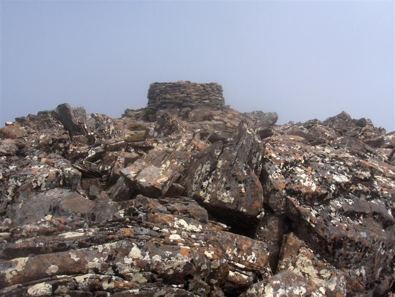
For those interested in doing it, it is worth noting you can no longer access Peak Rivulet road from either Creekton or Adamsons road. Take the Esperance road turn off (at the point the Hwy crosses the Esperance river) and follow the "Forest Tour" signs onto Peak Rivulet road. The track head is well marked along this road. You can also get onto Peak Rivulet road via the Old Hastings road turn off (to Duckhole Lake amongst other places) which is several kms past Strathblane. I would be keen to hear what people know about the origin of this track and who built the now collapsed stone hut and the massive cairn on the summit.
-

bluewombat - Athrotaxis cupressoides

- Posts: 327
- Joined: Sun 10 Feb, 2008 3:55 pm
- Region: Tasmania
3 posts
• Page 1 of 1
Who is online
Users browsing this forum: No registered users and 50 guests