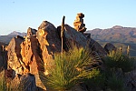
I would like the precise co-ordinates of North Geryon, South Geryon, and The Foresight, so that when I try and mimic photos in Google Earth, I can work out from where they were taken. The problem is: exactly where are these peaks? Here's the classic view of the three, looking over the Labyrinth from Walled Mt, with a GE mimic below it (GE has problems in this area; see below).
Ques 1
Are the lakes I've named correct?
Here's my problem:
• Placenames Tasmania only knows Mt Geryon, it is not subdivided.
• Google Earth is not capable of showing the classic view of Geryon showing the three separate peaks.
• The 1:25000 Tasmap, Du Cane, does not show the three peaks. Below is a 100% crop from that map:
Ques 2
On the Tasmap, what are the co-ordinates of the three Geryons?
Google Earth Elevation errors
It appears that GE has elevation errors that do not allow it to show the Geryon/Acropolis summits, even approximately. I've finally realised that's why I couldn't locate the three Geryons in GE. Here's a kmz file (https://www.mediafire.com/file/xyqf7i3n ... n.kmz/file) that takes you to what I think is Spot Height 1507 on the Tasmap (just above "Mt Geryon")
Ques 3
What are the GE co-ordinates (lat, long, decimal minutes please) of the three Geryons? Once I have these, I can accurately put a name to where Chris's photos were taken from.
Note that the "dashed" area west of Mt Geryon between two creeks (a boulder field) is also visible in the 1950 photo from Walled Mt and the GE mimic.