Can anyone tell me about access to the King William Range? I expect there is a track heading up from somewhere on the highway just west of Derwent Bridge but have never seen anything obvious.
Also, once you're into the range, what's the walking like? Tracks up peaks or off track? Campsites?
Cheers
Wello
King William Range
Forum rules
Tasmania specific bushwalking discussion. Please avoid publishing details of access to sensitive areas with no tracks.
Tasmania specific bushwalking discussion. Please avoid publishing details of access to sensitive areas with no tracks.
4 posts
• Page 1 of 1
King William Range
![]() by wello » Thu 05 Mar, 2009 6:21 pm
by wello » Thu 05 Mar, 2009 6:21 pm
- wello
- Athrotaxis cupressoides

- Posts: 147
- Joined: Sat 05 Apr, 2008 10:43 am
Re: King William Range
![]() by ollster » Fri 06 Mar, 2009 7:21 am
by ollster » Fri 06 Mar, 2009 7:21 am
Been up William 1, but no further. Yes, there is a 4wd track leading all the way to the base of the mtn. From there I recall it was quite a short up and back.
It was a while ago now, so I can't recall details. I do recall the 4wd track was pretty obvious on the big map they had at the Derwent Bridge pub. We pretty much guessed our way there, but it wasn't hard.
It was a while ago now, so I can't recall details. I do recall the 4wd track was pretty obvious on the big map they had at the Derwent Bridge pub. We pretty much guessed our way there, but it wasn't hard.
"I refuse to join any club that would have me as a member."
-
ollster - Lagarostrobos franklinii

- Posts: 3983
- Joined: Tue 02 Sep, 2008 4:14 pm
- ASSOCIATED ORGANISATIONS: LoveMyGoat.com
- Region: Australia
Re: King William Range
![]() by stu » Fri 06 Mar, 2009 7:25 am
by stu » Fri 06 Mar, 2009 7:25 am
Hi Wello,
I have only been up to KWI as a day trip, also taking in Milligans Peak & Mt. Pitt.
This is a really fantastic day trip & from memory only took about 4-5 hours return.
There is a very good track to KWI; to get to this:
-about 10ks (or so) west along the Lyell Hwy from Derwent Bridge,
-turn left onto a gravel road just after crossing the bridge over Navarre River & follow for about a k
-park next to the boom gate on the right signifying the start of the 4WD track
-follow this for maybe 3-4k; the 4WD track will stop & a walking track with register box will take you to the summit of KWI (complete with array of weather station equipment).
-the off track walking to Milligans Peak & Mt. Pitt is delightfully easy on alpine grasses / heaths.
Haven't been any further along the range than here yet so can't really comment, tho it is supposed to be pretty easy gouing apart from King William gap;
a classic old tale of a traverse of both the KW's & POW's ranges (The Royal Traverse) here:
http://www.subw.org.au/archives/POR/Thrash.html
I have also been in to Mt. Hobhouse which initially follows the track which takes you to KWII etc.
To get to this:
-take a left along the Butlers Gorge Road just before Tarraleah & follow right to the end to the Clark Dam, park here.
-sneak through the baricade (you can squeeze through without your pack on, which can be lowered from above), walk along the dam & clamber around the fence at the other end (I shouldn't promote ninja missions, but everyone else seems to do it ).
).
-follow the very good track which goes around the shore of Lake King William (or what is left of it).
-you will eventually come to an unexpected register box for the KW areas, which from what we gleaned gets very little use (I think we were the second entry in over 6 months).
-keep following the tracks to Lake Rufus (I think?) - maybe others who have been there could comment.
Hope this helps, if only a little.
Cheers.
Stu B.
I have only been up to KWI as a day trip, also taking in Milligans Peak & Mt. Pitt.
This is a really fantastic day trip & from memory only took about 4-5 hours return.
There is a very good track to KWI; to get to this:
-about 10ks (or so) west along the Lyell Hwy from Derwent Bridge,
-turn left onto a gravel road just after crossing the bridge over Navarre River & follow for about a k
-park next to the boom gate on the right signifying the start of the 4WD track
-follow this for maybe 3-4k; the 4WD track will stop & a walking track with register box will take you to the summit of KWI (complete with array of weather station equipment).
-the off track walking to Milligans Peak & Mt. Pitt is delightfully easy on alpine grasses / heaths.
Haven't been any further along the range than here yet so can't really comment, tho it is supposed to be pretty easy gouing apart from King William gap;
a classic old tale of a traverse of both the KW's & POW's ranges (The Royal Traverse) here:
http://www.subw.org.au/archives/POR/Thrash.html
I have also been in to Mt. Hobhouse which initially follows the track which takes you to KWII etc.
To get to this:
-take a left along the Butlers Gorge Road just before Tarraleah & follow right to the end to the Clark Dam, park here.
-sneak through the baricade (you can squeeze through without your pack on, which can be lowered from above), walk along the dam & clamber around the fence at the other end (I shouldn't promote ninja missions, but everyone else seems to do it
-follow the very good track which goes around the shore of Lake King William (or what is left of it).
-you will eventually come to an unexpected register box for the KW areas, which from what we gleaned gets very little use (I think we were the second entry in over 6 months).
-keep following the tracks to Lake Rufus (I think?) - maybe others who have been there could comment.
Hope this helps, if only a little.
Cheers.
Stu B.
- Attachments
-
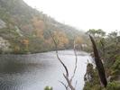
- Lake George & Lake King William from KWI ascent. Mt. Hobhouse & Wylds Craig in distance.
-
- Milligans Peak & KWI from Mt. Pitt.
-
- Mt. Pitt & Frenchmans Cap ranges from Milligans Peak summit.
Last edited by stu on Fri 06 Mar, 2009 12:26 pm, edited 1 time in total.
-

stu - Lagarostrobos franklinii
- Posts: 2174
- Joined: Fri 02 May, 2008 8:31 am
- Region: Tasmania
Re: King William Range
![]() by frank_in_oz » Fri 06 Mar, 2009 7:46 am
by frank_in_oz » Fri 06 Mar, 2009 7:46 am
stubowling wrote:Haven't been any further along the range than here yet so can't really comment, tho it is supposed to be pretty easy gouing apart from King William gap;
a classic old tale of a traverse of both the KW's & POW's ranges (The Royal Traverse) here:
http://www.subw.org.au/archives/POR/Thrash.html
This really is a must read yarn. I love the carefree attitude and laconic way it is written. Excellent way to "do" this traverse as I would not even have the gonads to consider it, let alone do it!
Frank
Check out "Our Hiking Blog" Overland Track guide, Food to Go-recipe ideas and Trekking to Everest Base Camp.
Check out "Our Hiking Blog" Overland Track guide, Food to Go-recipe ideas and Trekking to Everest Base Camp.
-
frank_in_oz - Athrotaxis cupressoides
- Posts: 372
- Joined: Fri 02 Nov, 2007 12:43 pm
- Location: Geelong, Vic
4 posts
• Page 1 of 1
Who is online
Users browsing this forum: No registered users and 37 guests