On the way out we camped at Louisa Creek with the plan to head out early the next morning to Buoy Creek at Cox's Bight for another day exploring this fantastic area.
About 7pm on Monday 23rd we were cooking dinner and a bit of thunder and lightening started around us. We were well set up and as the rain started we retreated to the tent and tried to get some sleep. The rain continued all night and my wife was getting increasingly concerned as first her "Crocs" and then boots started to float in the vestibule of the tent. I was getting "a bit cross" with her as she was constantly unzipping the tent and checking on the water level (about 3" deep on her side while dry on mine). FINALLY we got some sleep as we (she) got used to the heavy rain and what sounded like wind in the trees.
We woke early keen to head off as the rain had stopped. Upon arising we worked out what the "wind" sound was, it was the Louisa Creek in ?full flood. Boy that little, foot deep stream had risen overnight. It was now a 2.5 - 3 m torrent.....
We wacked a marker stick in to gauge if the river was rising and within a couple of minutes the water had risen beyond the stick and was heading to our tent. Discretion being the better part of valor and finally agreeing with my wife that "yes dear, the river could flood our tent", we moved to higher ground and check out the crossing.
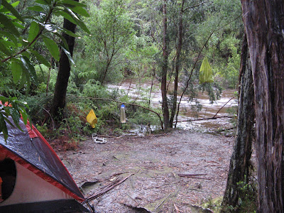
Early in am at Louisa Creek- the river ended up running though our site at about one foot deep an hour later
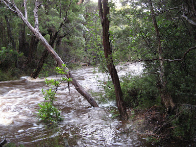
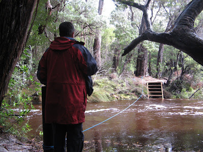
This one is downstream from our old site to the new river crossing steps and rope
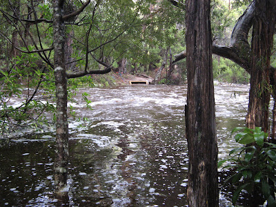
The picture above shows the top step of the new river crossing at Louisa Creek about 7am. There are about 10 steps down to the "usual" crossing depth. Within the next hour the water was about a foot above the top step and running through our original camp site. We decided to retire for breakfast......
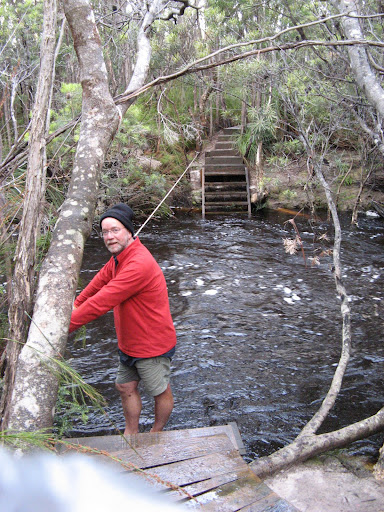
Over the next 4 hours we watched the level gradually retreat until 7 steps were visible. Below is Sue, checking out the steps on the Louisa River side of the "creek" and the rope. The water would have still been over a metre deep (and running "rather quickly")
As the river level at Louisa Creek has fallen a lot, we decided at about 1200 to walk the 700 m over to Faraway Creek and check out if it was possible to get across that day. When we arrived we were STUNNED, we thought the level would have dropped at around the same rate as Louisa Creek but this one was even higher. I think we were so stunned we forgot to take a picture but the water was a foot above the flood warning sign and RISING rapidly. Faraway Creek was running even faster and stronger than Louisa Creek.
We retreated to Louisa Creek and lunch (well a modified lunch, we were thinking if the rain kept up we might need to stretch our food out for a few days.....) It was again raining heavily On our return, Louise Creek had risen to the top of the steps again. Boy these rivers are responsive to rain!
We waited until about 4pm and Louisa Creek had fallen again so we walked over to Faraway Creek again and discovered it had fallen DRAMATICALLY AND there were about 20 South Coast Track hikers on the other side........ After about an hour the level had dropped enough to warrant an attempt to cross and I ended up getting 3 of the more adventurous across (including a non swimmer). We made a snap decision to head back to our gear, pack up and get across.
By now, 6 people in total had crossed and the rest had decided to camp on the Melaleuca side of the river until morning. (There are no designated campsites on that side of the river) We crossed pretty easily (about a metre of very fast water)
Looking back after getting across. The water was about 2 feet above the top piece of step you can see on the far side.
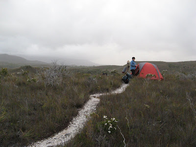
We headed through the temporary village that had been created at about 7pm and walked on for about 2km in our Crocs , finding a great spot next to the track and set up for the night, VERY happy to have the last major river crossing behind us.
Next day we did 23km into Melaleuca and had a couple of nights around there. I ran into a guy who had flown in to check out the area after I think, abandoning a walk at I THINK 5 mile creek in the Arthurs area. They woke to water filling their tent in the middle of the night and a VERY CLOSE NEAR DROWNING incident. He recalled standing with his pack on, water to his chest with no where to go. He thought he was going to die and the look in his eyes told us it was true. The party lost 3 cameras, multiple gear including boots etc. He was VERY happy to be out.
LESSONS:
1) Chapman is right, you must leave spare time in case you are held up by high rivers etc
2) Spare meals are very handy
3) It can be VERY boring watching a river drop, take some cards or a good book and chill.
4) It is TOTALLY out of your control, accept it (we talked to some very cross people who now had to flog themselves across the track to finish at a certain time) We had 2 spare days.
I am sure there are plenty more but work calls.
More on the trip soon and maybe a pic for the comp!
edit - spelling etc