Hi guys,
I'm planning on walking the Western Arthurs in a week or 2, and wondering how many days this will take. I've read everything from 6 to 11 days (big difference!!!). I'm a pretty keen walker, so hoping 7 might be about right. How hard would you rate it (I've done the Overland and South Coast track with ease, except for the Ironbounds!!!) and how much pack hauling is involved? (how much rope to take!!!). I'm buying the Chapman book which will possibly help me a lot, but would love to hear from fellow walkers!!!
Thanks,
Maarten
western arthurs
Forum rules
Tasmania specific bushwalking discussion. Please avoid publishing details of access to sensitive areas with no tracks.
Tasmania specific bushwalking discussion. Please avoid publishing details of access to sensitive areas with no tracks.
20 posts
• Page 1 of 1
western arthurs
![]() by Dutchy » Mon 15 Dec, 2008 8:51 pm
by Dutchy » Mon 15 Dec, 2008 8:51 pm
Last edited by Dutchy on Tue 16 Dec, 2008 8:01 pm, edited 1 time in total.
-

Dutchy - Athrotaxis cupressoides

- Posts: 168
- Joined: Thu 25 Sep, 2008 3:58 pm
- Location: Melbourne
Re: western arthurs
![]() by ollster » Mon 15 Dec, 2008 9:09 pm
by ollster » Mon 15 Dec, 2008 9:09 pm
I would probably have to say that the OLT and South Coast are not comparable to the Western Arthurs. If the OLT/South Coast are 3/10, then the arthurs are 7/10 in terms of difficulty.
When I did it we did:
-2h30m to the crossing camp (Day 1)
-6 days in the range itself, including one half day at a lake in the sun, and one full day at Lake Roseanne under the big rock with the rain hammering in.
-Then walked out along the Huon Track (Day 7, plus out at about 1pm on day 8.)
We did some quite stupidly long days on the 6 days in the range - 5 of them were from 9.5 up to over 12 hours actual walking. It was a bad idea, it killed my knees, and if I did the range again I'd do it slower. I'd also not advise coming out on the Huon track, as it's hell booring.
That was in 1996 (I think) and I dunno what the track is like now, but I think the campsites are better. Some of the track was very dodgy when I did it. Coming down of Capricorn (?) was terrifying (but I'm scared of heights...). The beggary bumps are also Hard Work. I think that was basically a whole day witout a flat bit of ground.
Water can be a big problem on some sections. Carry extra gas in case you need to boil water from ponds, as there may not be water on some sections. We had a full 10 hour day without any running water, and I had to resort to sucking water out of a hole in the ground...
Absolutely take a rope, if you're not sure. Prepare for anything/everything, as it could snow even is summer.
It's one of the best walks you can do in Tassie, so enjoy, it will be an experience.
"I refuse to join any club that would have me as a member."
-

ollster - Lagarostrobos franklinii

- Posts: 3983
- Joined: Tue 02 Sep, 2008 4:14 pm
- ASSOCIATED ORGANISATIONS: LoveMyGoat.com
- Region: Australia
Re: western arthurs
![]() by Azza » Mon 15 Dec, 2008 9:44 pm
by Azza » Mon 15 Dec, 2008 9:44 pm
I would agree with Ollster.
7 Night probably enough for Moraine A to K and back the Scotts Pk, not the full traverse.
First day 3hrs or so into the Junction Creek, then up Moraine A to Lake Cygnus. Thats pretty much a full day.
2nd day is a half day to Lk Oberon. You can't really go any further because Oberon to High Moor is a long day.
The track to Oberon from the top of Moraine A is well maintained but beyond Oberon things get much
more remote and less well defined and the time between camps site is quick long and you don't really have
many options available. If your not sure, consider just going as far as Lk Oberon. Beyond there you are committing
yourself and don't really have much choice as there are no interim camp sites.
Sections such as the begary bumps will be sure to test out the hardened walker amongst us.
First time I ever went into the Arthurs we turned around at Oberon because the weather was absolutely dreadful
and we'd under estimated the time we'd required.
Rope wise - I generally carry ~4-5m of 3mm clothes line thickness cord. I didn't need it for the Western Arthurs, but
there are a couple of sections beyond Lk Oberon where it might be safer to lower or raise your pack.
(It comes in handy when walking with the Ollster and he gets a bit shacky....)
Like Ollster I've done things a bit too quickly in the past... and the end result was a 14hour day, one stuffed knee
and a crashed the car in the scotts pk car part at 12am..
(in hindsight it probably wasn't such a bad thing...)
-
Azza - Phyllocladus aspleniifolius

- Posts: 980
- Joined: Thu 06 Mar, 2008 11:26 am
Re: western arthurs
![]() by lexharris » Mon 15 Dec, 2008 9:58 pm
by lexharris » Mon 15 Dec, 2008 9:58 pm
ollster wrote:I would probably have to say that the OLT and South Coast are not comparable to the Western Arthurs. If the OLT/South Coast are 3/10, then the arthurs are 7/10 in terms of difficulty.
I'd agree with ollster there. The full Western Arthurs traverse is probably one of the most challenging of established tracks in Tasmania. Level of difficulty would depend on your age, level of fitness and experience. I think for a fit experienced walker 7 days would be reasonable from Moraine A to Lucifer Ridge or vice versa. There is a lot of really steep up-down and it can be pretty hard on the knees with the inevitably heavy pack. Last time I walked the main range (2001) we had to abort after 5 days, one of our party of three had done a knee and he was a big strong fit guy too. Do you need a rope? Not really, we certainly didn't need one in 2001 from Moraine A to Moraine K, nor in 2005 when I went back and walked the rest from Moraine K to Federation Peak. There are some parts where you definitely must pack haul but with two or more you can just pass packs to each other or if you're solo you can break your load into sections and double haul .
Having said all that it's one of the most rewarding walks I've done and well worth it. Good luck and don't forget your camera!
BTW the Ironbound R is a picnic by comparison
- Attachments
-
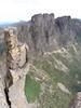
- Lakes Promontory, Vesta, Juno; Centaurus Ridge, Crags of Andromeda, Eastern Arthurs and Federation Pk; from summit of Mt Scorpio.
Photo Matt Sherlock. - Scorpio summit.jpg (131.54 KiB) Viewed 12461 times
Wilderness is not a luxury but a necessity of the human spirit. ~ Edward Abbey (1927-1989)
- lexharris
- Athrotaxis cupressoides
- Posts: 115
- Joined: Thu 13 Nov, 2008 2:48 pm
Re: western arthurs
![]() by ollster » Mon 15 Dec, 2008 10:05 pm
by ollster » Mon 15 Dec, 2008 10:05 pm
Coming down off this bit with a 25kg+ pack scared me. I remember it quite vividly...
http://www.hugin.com.au/warthurs/pages/ ... 0Climb.htm
http://www.hugin.com.au/warthurs/pages/ ... 0Climb.htm
"I refuse to join any club that would have me as a member."
-
ollster - Lagarostrobos franklinii
- Posts: 3983
- Joined: Tue 02 Sep, 2008 4:14 pm
- ASSOCIATED ORGANISATIONS: LoveMyGoat.com
- Region: Australia
Re: western arthurs
![]() by lexharris » Mon 15 Dec, 2008 10:15 pm
by lexharris » Mon 15 Dec, 2008 10:15 pm
ollster wrote:Coming down off this bit with a 25kg+ pack scared me. I remember it quite vividly...
http://www.hugin.com.au/warthurs/pages/ ... 0Climb.htm
Oh yeah, I remember that bit, wasn't it straight off the summit of Capricorn? Seemed like just a series footholds cut into peat or something in the side of a near vertical slope. 25kg? Only carrying your day pack eh?
Wilderness is not a luxury but a necessity of the human spirit. ~ Edward Abbey (1927-1989)
- lexharris
- Athrotaxis cupressoides
- Posts: 115
- Joined: Thu 13 Nov, 2008 2:48 pm
Re: western arthurs
![]() by Robbo » Mon 15 Dec, 2008 10:17 pm
by Robbo » Mon 15 Dec, 2008 10:17 pm
lexharris wrote: ollster wrote:I would probably have to say that the OLT and South Coast are not comparable to the Western Arthurs. If the OLT/South Coast are 3/10, then the arthurs are 7/10 in terms of difficulty.
I'd agree with ollster there.
I'd agree as well. My son and I walked it in January this year. We took 8 days from Scotts Peak rtd. 1 day to Junction Creek and another from Junction Creek to Car Park. We did not need a rope, but had to take off our packs a couple of times. We had good weather for most of the time - overcast and cold from Oberon to High Moor. Had short day from Haven to Vesta after we decided that we wouldn't do the full traverse to Cracroft. A long boring day from Vesta back to Junction Creek along Arthurs Plains - it had been burnt the year before and because it was so dry.
We found the walk fine as we took our time and simply walked to within our limitations. I think most would find it the same as long as it is approached with a careful attitude, good gear and proper preparation.
Tony Robinson
"The place between your comfort zone and your dream is where your life takes place." Nick Vujicic.
-
Robbo - Athrotaxis cupressoides
- Posts: 288
- Joined: Sat 07 Jun, 2008 8:31 pm
- Location: Melbourne
- ASSOCIATED ORGANISATIONS: Gilson College
- Region: Victoria
- Gender: Male
Re: western arthurs
![]() by Son of a Beach » Tue 16 Dec, 2008 8:11 am
by Son of a Beach » Tue 16 Dec, 2008 8:11 am
If you have the stamina and fitness, and if you start early enough in the morning, you can walk in to lake Cygnus in one long very hard day, which is much more interesting first day, than just trudging to Junction Creek (recommended only for parties that are sure they can handle walking up a steep hill through mud for hours on end, after walking across plains through mud for hours on end). I've done this distance both ways, and it is extremely knackering, but it can be done.
There are also a couple of other options for a first night's camp site between Junction Creek and the top of Morraine A to make the first day a little longer and the second day a little shorter if you want to do it in 2 days to Lake Cygnus. There's a small stand of forest in the plains a bit before where the Morraine A (Western Arthurs) track branches off from the Port Davey track. There used to be an old two or three sided shelter here, apparently, but there are still a few good spots to pitch a tent (and there's a creek nearby). If you want to go further still, there are some very dodgy campsites right at the base of Morraine A, just as the track starts going up. Look out for where the track goes right past a very large cuboid boulder. There are some slightly muddy camp sites between the track and the boulder (amonst some bushes) and a few metres further on as well. There's a small creek nearby. I slept under the boulder with no tent one time - turned out to be the best night's sleep I've ever had bushwalking without the aid of pain killers. The ground under the boulder is dusty but dry most of the time.
There are also a couple of other options for a first night's camp site between Junction Creek and the top of Morraine A to make the first day a little longer and the second day a little shorter if you want to do it in 2 days to Lake Cygnus. There's a small stand of forest in the plains a bit before where the Morraine A (Western Arthurs) track branches off from the Port Davey track. There used to be an old two or three sided shelter here, apparently, but there are still a few good spots to pitch a tent (and there's a creek nearby). If you want to go further still, there are some very dodgy campsites right at the base of Morraine A, just as the track starts going up. Look out for where the track goes right past a very large cuboid boulder. There are some slightly muddy camp sites between the track and the boulder (amonst some bushes) and a few metres further on as well. There's a small creek nearby. I slept under the boulder with no tent one time - turned out to be the best night's sleep I've ever had bushwalking without the aid of pain killers. The ground under the boulder is dusty but dry most of the time.
- Son of a Beach
- Lagarostrobos franklinii
- Posts: 7024
- Joined: Thu 01 Mar, 2007 7:55 am
- ASSOCIATED ORGANISATIONS: Bit Map (NIXANZ)
- Region: Tasmania
- Gender: Male
Re: western arthurs
![]() by stu » Tue 16 Dec, 2008 8:36 am
by stu » Tue 16 Dec, 2008 8:36 am
We did it last November in 8 days; note - being keen peak baggers we did all the side trips, ie. 18 of the 19 listed peaks (Shaula was missed due to time constraints + the hardest peak to access off the range, we will do this one from the plains at some stage).
Day 1 we went from Scotts Peak to Lake Fortuna which felt fairly long - Lake Cygnus is not far from here tho if you can push on a little longer.
The next 6 days were fairly casual, even with all the peak bagging. We generally didn't start walking til after 9am each morning.
From Promontory lake to Lake Roseanne (day 7) was quite a long day (with side trips to Canopus & the true (eastern) summit of West Portal); the crags of Andromeda were a little tedious by late in this day.
Day 8 we went from Lake Rosanne all the way back to Scotts Peak, about 29 k's? (coming off the range from Rosanne we headed off track diagonally west avoiding the Razorback & about an extra 5 k's; the Arthur Plains being burnt out it was open most of the way until we hit the track again). This was a long boring day, about 9.5 hours. Probably expect it to be boring after the excitement of the previous week.
The only section you may need to pack haul is at the top of the Tilted Chasm due to rotten rock - carry a 10m 5mm line & you should be ok. You may also need it going up Pegasus, tho the rock is solid & the holds good so you'd probably be ok.
I can't wait to get back there again someday, my favourite walk, it will be good to do it more casually next time. I'm not sure we'd be as lucky with the weather again tho - we only had 20 minutes of drizzle in 8 days; hope you get as lucky!
Have fun & take heaps of photos; walks don't get much better than this one
Stuart.
-

stu - Lagarostrobos franklinii
- Posts: 2174
- Joined: Fri 02 May, 2008 8:31 am
- Region: Tasmania
Re: western arthurs
![]() by Dutchy » Tue 16 Dec, 2008 6:32 pm
by Dutchy » Tue 16 Dec, 2008 6:32 pm
Thanks for all your fast replies.
I'm considering to go up A Moraine and down K Moraine, which is meant to be about 7 days. Has anyone done the "shortcut" through E Moraine? What part would be the best to do? A -E or E - K? And how many days?
Thanks heaps!!!!
I'm considering to go up A Moraine and down K Moraine, which is meant to be about 7 days. Has anyone done the "shortcut" through E Moraine? What part would be the best to do? A -E or E - K? And how many days?
Thanks heaps!!!!
-
Dutchy - Athrotaxis cupressoides
- Posts: 168
- Joined: Thu 25 Sep, 2008 3:58 pm
- Location: Melbourne
Re: western arthurs
![]() by Azza » Tue 16 Dec, 2008 6:57 pm
by Azza » Tue 16 Dec, 2008 6:57 pm
I have not done Moraine E, but last time I was up the Arthurs it was offically closed by parks and wildlife.
From lake Oberon its actually quicker to walk all the way back and down Moraine A rather than Moraine E.
i.e. Its not a shortcut...
That gives you an idea what the route it like. Its not well marked at the arthur plains end, although I can't
say I've ever spent a lot of time looked for it. The route itself is suppost to be fairly scrubby and there are
some difficult bands of cliffs to negotiate.
So you're better off either doing Moraine A to Oberon return or Moraine A-K.
-
Azza - Phyllocladus aspleniifolius
- Posts: 980
- Joined: Thu 06 Mar, 2008 11:26 am
Re: western arthurs
![]() by norts » Tue 16 Dec, 2008 7:39 pm
by norts » Tue 16 Dec, 2008 7:39 pm
WA's is the best walk I have done in Tassie. I have done it twice. Last time was Feb this year.
My itinerary
1st Junction , Cygnus, Oberon, High Moor(2 nights bad weather), Haven, 7 Mile
2nd Junction, Cygnus, Oberon, High Moor, Haven(2 nights bad weather) junction
It is not an easy walk, but the rewards a great.
The first trip we were doubling Chapmans shortest times for nearly every leg. We were stopping alot to just take it all in.
1st trip only time we had to take packs off was to pass them through the boulders above Oberon.
2nd time did 1 extra pack hall.
There is alot of erosion.
Allow a couple of days at least for bad weather.
Roger
-
norts - Lagarostrobos franklinii
- Posts: 2013
- Joined: Wed 01 Aug, 2007 10:45 am
- Location: Germantown Tas.
- Region: Tasmania
Re: western arthurs
![]() by Dutchy » Tue 16 Dec, 2008 7:44 pm
by Dutchy » Tue 16 Dec, 2008 7:44 pm
So Moraine A - K it will be. I'm a pretty fit walker, so 7 days should be enough? I'm not planning to run (or climb) up every peak I pass, that might be for when I come back for a second trip... Can anyone tell me how long the drive to Scott's peak dam will be from Hobart?
Thanks again!
Thanks again!
-
Dutchy - Athrotaxis cupressoides
- Posts: 168
- Joined: Thu 25 Sep, 2008 3:58 pm
- Location: Melbourne
Re: western arthurs
![]() by ollster » Tue 16 Dec, 2008 7:46 pm
by ollster » Tue 16 Dec, 2008 7:46 pm
I think the drive to Scott's peak is something like 4 hours. Someone else may have a better idea though.
"I refuse to join any club that would have me as a member."
-
ollster - Lagarostrobos franklinii
- Posts: 3983
- Joined: Tue 02 Sep, 2008 4:14 pm
- ASSOCIATED ORGANISATIONS: LoveMyGoat.com
- Region: Australia
Re: western arthurs
![]() by Dutchy » Tue 16 Dec, 2008 8:00 pm
by Dutchy » Tue 16 Dec, 2008 8:00 pm
norts wrote:WA's is the best walk I have done in Tassie. I have done it twice. Last time was Feb this year.
My itinerary
1st Junction , Cygnus, Oberon, High Moor(2 nights bad weather), Haven, 7 Mile
2nd Junction, Cygnus, Oberon, High Moor, Haven(2 nights bad weather) junction
Hi Roger,
So if I get you right, you walked for 6 days both times with 2 days of bad weather?
Was that with or without sidetrips? And are those days reasonable or full on?
Thanks
-
Dutchy - Athrotaxis cupressoides
- Posts: 168
- Joined: Thu 25 Sep, 2008 3:58 pm
- Location: Melbourne
Re: western arthurs
![]() by Son of a Beach » Tue 16 Dec, 2008 8:02 pm
by Son of a Beach » Tue 16 Dec, 2008 8:02 pm
I've done the Arthurs a couple of times too. The first time was from Moraine K to Moraine A. I'd recommend doing it this way around as you end up with a slightly shorter last day across the plains, and a slightly longer first day across the plains, and it seems to make the best use of the time to me. We did it in 6 days. We had planned to stay at Square lake on the last night, (ie, had planned for 7 days), but combined the last two days into one long one as it was bucketing rain and we preferred to walk out in the rain in one day rather than 2 days and an extra night camping in the rain. Our itinerary was:
7 Mile Creek
Haven Lake
High Moor
Lake Oberon
Lake Cygnus
(Square Lake - Cancelled)
That last day was quite long, but not as long as doing it the other way around which I've also done (1 day into Lake Cygnus).
If you have more time, doing the entire range is even better, of course, but you'd need to allow a couple of extra days. The other end of the range is quite a contrast, I reckon, so you get more variety of scenery when doing the full length.
EDIT: Actually, I didn't even see Square Lake at all on the first trip, due to the bad weather. I was surprised at how close the track went to it, and how much a view of it I should have had, when I saw it on my second trip through.
- Son of a Beach
- Lagarostrobos franklinii
- Posts: 7024
- Joined: Thu 01 Mar, 2007 7:55 am
- ASSOCIATED ORGANISATIONS: Bit Map (NIXANZ)
- Region: Tasmania
- Gender: Male
Re: western arthurs
![]() by lexharris » Tue 16 Dec, 2008 8:29 pm
by lexharris » Tue 16 Dec, 2008 8:29 pm
Our itinerary for Moraine A -K was:
Day 1 Hobart to Scotts to base of Moraine A
Day 2 Moraine A to Oberon
Day 3 Oberon to High Moor
Day 4 Tentbound High Moor (big hailstorm)
Day 5 High Moor to Haven Lake
Day 6 Haven Lake to 7 Mile Creek
Day 7 7 Mile to Junction Creek
Day 8 Junction Creek to Scotts to Hobart
Days 1-5 were normal progress for fit party
Days 6,7,8 were slow due to one party member with torn knee ligament
Wilderness is not a luxury but a necessity of the human spirit. ~ Edward Abbey (1927-1989)
- lexharris
- Athrotaxis cupressoides
- Posts: 115
- Joined: Thu 13 Nov, 2008 2:48 pm
Re: western arthurs
![]() by DaveNoble » Tue 16 Dec, 2008 10:50 pm
by DaveNoble » Tue 16 Dec, 2008 10:50 pm
If you intend to do the "Arthurs" - then you should definitely do a complete traverse from Moraine A to Lake Rosanne (that is if you intend to do the Western Arthur Range) but it is much better to do a full traverse all the way to Federation Peak (ie all the "Arthurs"). This should take about 11 days from Scotts Peak return. I would not advise going down Moraine K - if you go that way you only do 3/4 of the Western Arthurs and miss out on some great country.
Back in 1975 we took 5 days to go from Junction Creek to Craycroft Crossing - this included one day stormbound at Lake Oberon. The route is a MUCH better track now and very well marked. So I would think 4 days walking is adequate for the range - but remember to allow extra days for bad weather and also it is nice to go slower and stop early to enjoy the country. If you can scramble OK - then there is no need for any rope (except perhaps for the optional Orion-Procyon traverse)
Dave
- DaveNoble
- Athrotaxis selaginoides

- Posts: 1031
- Joined: Sun 03 Feb, 2008 3:56 pm
Re: western arthurs
![]() by Swifty » Wed 17 Dec, 2008 7:35 pm
by Swifty » Wed 17 Dec, 2008 7:35 pm
Just to add a bit about Moraine E, I descended that way from Lake Oberon in May 1983. It was a bit of a slog, didn't or can't recall encountering any cliffs, but the matted buaera, ti tree and cutting grass were somthing else! Wading through, 10' off the deck and occasionally slipping through. I don't think there is a clear way down. By contrast, Moraine K (if you ever need to choose between the two) is a lovely open ridge.
Swifty
Ossua vetera
Ossua vetera
-

Swifty - Athrotaxis cupressoides
- Posts: 370
- Joined: Wed 10 Dec, 2008 3:56 pm
- Location: Perth
- Region: Western Australia
- Gender: Male
Re: western arthurs
![]() by Dutchy » Thu 18 Dec, 2008 4:40 am
by Dutchy » Thu 18 Dec, 2008 4:40 am
DaveNoble wrote:If you intend to do the "Arthurs" - then you should definitely do a complete traverse from Moraine A to Lake Rosanne (that is if you intend to do the Western Arthur Range) but it is much better to do a full traverse all the way to Federation Peak (ie all the "Arthurs"). This should take about 11 days from Scotts Peak return. I would not advise going down Moraine K - if you go that way you only do 3/4 of the Western Arthurs and miss out on some great country.
Dave
I'll save that one for another time.... I'll stick to A - K for now. If that goes all ok, I'll be back for the full traverse!!! There is always more to see and to do.....
Dutchy
-
Dutchy - Athrotaxis cupressoides
- Posts: 168
- Joined: Thu 25 Sep, 2008 3:58 pm
- Location: Melbourne
20 posts
• Page 1 of 1
Who is online
Users browsing this forum: No registered users and 35 guests