Hi everyone,
I'm looking at walking in on the Arm River Track into Pelion and doing Ossa after Christmas. Couple of questions:
- What is the Arm River track like into Pelion? e.g. well marked? track condition? etc
- I'm not sure whether to do Ossa then walk out the same way, or to continue down to Lake St Claire. Does anyone know if this is still possible with the Overland Track booking system?
Thanks in advance!
Andrew
Arm River Track into Pelion
Forum rules
Overland Track App
An electronic guidebook for planning and walking the Overland Track.
Download this app for loads of information about planning, gear, food, accommodation and much more about the Overland Track.
You will also find topo maps, terrain profiles and track notes for offline use.
$10 -- Discount to $3 until December 15
17 posts
• Page 1 of 1
Arm River Track into Pelion
![]() by murrayap » Tue 08 Dec, 2009 9:55 pm
by murrayap » Tue 08 Dec, 2009 9:55 pm
- murrayap
- Nothofagus cunninghamii

- Posts: 6
- Joined: Sun 02 Aug, 2009 9:16 am
- Region: Tasmania
- Gender: Male
Re: Arm River Track into Pelion
![]() by E.G. » Wed 09 Dec, 2009 8:14 am
by E.G. » Wed 09 Dec, 2009 8:14 am
Hi Andrew,
The Arm River Track is very well marked and in good condition. There is some hard work in the first 30 minutes but after that it is good going, particularly after it picks up the old Mole Creek Track west of Warragarra Creek.
The booking system only applies to people walking the whole Overland Track. Its rules don't apply if you walk only part of the track. You should try walking against the traffic. You get some interesting questions then.
Cheers
E.G.
-

E.G. - Nothofagus gunnii

- Posts: 47
- Joined: Fri 09 May, 2008 5:56 pm
- Region: Tasmania
Re: Arm River Track into Pelion
![]() by sthughes » Wed 09 Dec, 2009 8:31 am
by sthughes » Wed 09 Dec, 2009 8:31 am
The Arm river track is very well marked, boardwalked in the boggy sections, bridged over all the creeks. Steep at first, but otherwise easyish.
OLT booking system only applies to people doing the whole thing, so all should be good! Have fun
Edit: Lol - bit late there! Must learn to refresh the page when I take so long between reading the question and replying!
OLT booking system only applies to people doing the whole thing, so all should be good! Have fun
Edit: Lol - bit late there! Must learn to refresh the page when I take so long between reading the question and replying!
"Don't do today what you can put off 'till tomorrow." (Work that is!)
-
sthughes - Lagarostrobos franklinii

- Posts: 2427
- Joined: Wed 05 Mar, 2008 12:53 pm
- Location: Ulverstone
- Region: Tasmania
- Gender: Male
Re: Arm River Track into Pelion
![]() by Michael_Kingston » Wed 09 Dec, 2009 6:06 pm
by Michael_Kingston » Wed 09 Dec, 2009 6:06 pm
Another (IMO) even more pleasant option is to go into Pelion via Lees Paddocks - once again straightforward walking. Pretty flat to Lees Paddocks, a bit of a climb and then easy going again.
As the others have said, there is no need for a permit as you are not doing the whole Overland Track. And if you do decide to go against the N-S Overland traffic and head North you will get every second walker telling you not to go that way, which can be fun itself! When I walked the Traveller Range in January we only went as far as Du Cane Gap (from Narcissus) but still managed to get into an entertaining argument with a woman from NSW who was going to report us for breaking the rules, wrecking eveyone's experience, not having a track permit etc etc.........
As the others have said, there is no need for a permit as you are not doing the whole Overland Track. And if you do decide to go against the N-S Overland traffic and head North you will get every second walker telling you not to go that way, which can be fun itself! When I walked the Traveller Range in January we only went as far as Du Cane Gap (from Narcissus) but still managed to get into an entertaining argument with a woman from NSW who was going to report us for breaking the rules, wrecking eveyone's experience, not having a track permit etc etc.........
- Michael_Kingston
- Athrotaxis cupressoides

- Posts: 108
- Joined: Sun 13 Sep, 2009 4:24 pm
- Region: Tasmania
- Gender: Male
Re: Arm River Track into Pelion
![]() by ILUVSWTAS » Wed 09 Dec, 2009 6:12 pm
by ILUVSWTAS » Wed 09 Dec, 2009 6:12 pm
Michael_Kingston wrote:
As the others have said, there is no need for a permit as you are not doing the whole Overland Track. And if you do decide to go against the N-S Overland traffic and head North you will get every second walker telling you not to go that way, which can be fun itself! When I walked the Traveller Range in January we only went as far as Du Cane Gap (from Narcissus) but still managed to get into an entertaining argument with a woman from NSW who was going to report us for breaking the rules, wrecking eveyone's experience, not having a track permit etc etc.........
Damn mainlanders....
damn overlanders.....
Nothing to see here.
-

ILUVSWTAS - Lagarostrobos franklinii
- Posts: 11046
- Joined: Sun 28 Dec, 2008 9:53 am
- Region: Tasmania
- Gender: Male
Re: Arm River Track into Pelion
![]() by Michael_Kingston » Wed 09 Dec, 2009 6:25 pm
by Michael_Kingston » Wed 09 Dec, 2009 6:25 pm
I don't think we should damn them all ILUVSWTAS - I enjoy a good argument. I also continue to have pleasant visions of her turning up at the Parks desk at the Lake St Clair visitors centre to report me in a fit of righteous indignation and then being told she is wrong.
- Michael_Kingston
- Athrotaxis cupressoides
- Posts: 108
- Joined: Sun 13 Sep, 2009 4:24 pm
- Region: Tasmania
- Gender: Male
Re: Arm River Track into Pelion
![]() by ILUVSWTAS » Wed 09 Dec, 2009 6:33 pm
by ILUVSWTAS » Wed 09 Dec, 2009 6:33 pm
Yeh that would have been quite a sight to be sure!
Couple of years ago while doing the SCT I had a couple from Victoria give me an earful for going "offtrack" on top the Ironbound range as I wanted a good look at PB.
Couple of years ago while doing the SCT I had a couple from Victoria give me an earful for going "offtrack" on top the Ironbound range as I wanted a good look at PB.
Nothing to see here.
-
ILUVSWTAS - Lagarostrobos franklinii
- Posts: 11046
- Joined: Sun 28 Dec, 2008 9:53 am
- Region: Tasmania
- Gender: Male
Re: Arm River Track into Pelion
![]() by GerryDuke » Wed 09 Dec, 2009 8:34 pm
by GerryDuke » Wed 09 Dec, 2009 8:34 pm
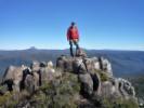
If you have time Andrew the diversion to Mt Pillinger from the Arm River Track is well worth the diversion. Fantastic 360 degree views.
Gerry
Gerry
-

GerryDuke - Athrotaxis cupressoides
- Posts: 403
- Joined: Sun 18 May, 2008 12:04 am
- Location: KINGSTON BEACH, TASMANIA
- ASSOCIATED ORGANISATIONS: Operator of www.TouringTasmania.info web site
- Region: Tasmania
- Gender: Male
Re: Arm River Track into Pelion
![]() by corvus » Wed 09 Dec, 2009 8:45 pm
by corvus » Wed 09 Dec, 2009 8:45 pm
The reedy lake track from Lees Paddocks is not as well defined in some places as
the Arm River Track and you would miss the opportunity to Climb MT Pillenger.
the Arm River Track and you would miss the opportunity to Climb MT Pillenger.
collige virgo rosas
-

corvus - Vercundus gearus-freakius

- Posts: 5538
- Joined: Mon 23 Apr, 2007 7:24 pm
- Location: Devonport
- Region: Tasmania
- Gender: Male
Re: Arm River Track into Pelion
![]() by murrayap » Wed 09 Dec, 2009 10:12 pm
by murrayap » Wed 09 Dec, 2009 10:12 pm
Thanks for the info so far everyone!
It's looking like I'll walk down to Lake St Claire after doing Ossa, although I'm sure the Overland track will be pretty busy at that time of year! What would be the walking time to come in via Mt Pillinger? i.e. from walk car park to Mt Pillinger to Pelion?
It's looking like I'll walk down to Lake St Claire after doing Ossa, although I'm sure the Overland track will be pretty busy at that time of year! What would be the walking time to come in via Mt Pillinger? i.e. from walk car park to Mt Pillinger to Pelion?
- murrayap
- Nothofagus cunninghamii
- Posts: 6
- Joined: Sun 02 Aug, 2009 9:16 am
- Region: Tasmania
- Gender: Male
Re: Arm River Track into Pelion
![]() by flyfisher » Thu 10 Dec, 2009 5:22 am
by flyfisher » Thu 10 Dec, 2009 5:22 am
About an easy day.
ff
ff
If you don't know what I'm talking about, then you need to drink more.
-
flyfisher - Athrotaxis selaginoides

- Posts: 1532
- Joined: Sat 14 Jul, 2007 8:39 pm
- Location: hobart
- ASSOCIATED ORGANISATIONS: landrover owners club of tasmania
- Region: Tasmania
Re: Arm River Track into Pelion
![]() by E.G. » Thu 10 Dec, 2009 7:55 am
by E.G. » Thu 10 Dec, 2009 7:55 am
About an easy day.
ff
If you have your skates on it would be about 0.8 (standard summer) E.D.
-
E.G. - Nothofagus gunnii
- Posts: 47
- Joined: Fri 09 May, 2008 5:56 pm
- Region: Tasmania
Re: Arm River Track into Pelion
![]() by vorn » Sun 27 Dec, 2009 11:59 pm
by vorn » Sun 27 Dec, 2009 11:59 pm
did arm river track last week
couple of small trees down but otherwise very good-about 3 1/2hrs into new pelion hut
steep climb at beginning (about 15mins in) is only 20mins of solid effort
we only walked the wrong walk up the overland track for about a km to the mt thetis track and still managed to get a few confused looks and polite questions as to where we were going in that short time
cheers
- vorn
- Nothofagus cunninghamii
- Posts: 5
- Joined: Tue 26 May, 2009 7:15 pm
- Region: Tasmania
Re: Arm River Track into Pelion
![]() by Michael_Kingston » Mon 28 Dec, 2009 6:23 am
by Michael_Kingston » Mon 28 Dec, 2009 6:23 am
Vorn - there you go confusing everyone by walking north. It never ceases to amaze me how concerned people get when they see someone going the 'wrong way.'
- Michael_Kingston
- Athrotaxis cupressoides
- Posts: 108
- Joined: Sun 13 Sep, 2009 4:24 pm
- Region: Tasmania
- Gender: Male
Re: Arm River Track into Pelion
![]() by donktec » Thu 18 Mar, 2010 11:51 am
by donktec » Thu 18 Mar, 2010 11:51 am
Hi all,
Rather than start a new threaed i thought i would post my question here as it seems the most relevant place.
Planning to head to New Pellion from the Arm River track at the end of April with some friends. I'm going to assume there are no big signposts "this way to overland track" from out on the highway, so I am wondering how easy is it to find the start (end) of the track when driving in? How easy is it to even find the road itself? Thanks!
A.
-

donktec - Nothofagus gunnii
- Posts: 49
- Joined: Thu 18 Mar, 2010 11:45 am
- Location: Melbourne
- Region: Other Country
- Gender: Male
Re: Arm River Track into Pelion
![]() by sthughes » Thu 18 Mar, 2010 1:01 pm
by sthughes » Thu 18 Mar, 2010 1:01 pm
The start of the track is shown on Google here: http://maps.google.com.au/maps?q=-41.789873,146.156702&num=1&t=p&sll=-25.335448,135.745076&sspn=38.161973,47.373047&ie=UTF8&ll=-41.789201,146.156745&spn=0.025214,0.038581&z=15
Basically follow the signs much of the way to the Walls of Jerusalem, pass the Parangana Dam (first big one), you will run out of bitumen eventually after skirting the lakeside, not too long after that you will cross a small river (the one that you can see a weir on the right side of the road just upstream of the bridge), this is the Arm River. Just after this there is a major T intersection (almost Y actually), turn right there. (If you come to a short section of bitumen with a picnic shelter on the left side of the road you have gone too far, do a U turn and go back).
Follow that road for 15-16km or so (don't turn left up the hill at a minor Y junction) and keep your eyes peeled for the small wooden Arm River Track sign. At this sign turn right again and no sooner said than done you are at the car park, such as it is. Should be pretty straight forward, it's a fairly popular spot.
Watch out for wildlife and especially log trucks. Have fun!
P.S. Assuming you are coming on the Spirit, firstly follow the signs to Cradle Mountain and Sheffield until you reach Gowrie Park (big mural on right side of road). A couple of minutes after that you turn left towards Lorinna (onto the C138). A bit further on, well past the first bendy stuff, Stay on the C138 (Olivers Road), at this intersection http://maps.google.com.au/maps?f=q&source=s_q&hl=en&geocode=&q=&sll=-41.541638,146.182194&sspn=0.025311,0.038581&ie=UTF8&ll=-41.541638,146.182194&spn=0.025311,0.038581&t=p&z=15it is quie easy to go straight ahead onto the C139 down to the Lemonthyme Powerstation and Lorinna. In case you are wondering, don't bother visiting Lorinna - it isn't worth it.
If you get on a gravel road before passing a big dam you are in the wrong place!
If you come to a second even bigger dam (on the gravel road) you have gone too far!
If you wind down a very steep hill to a significant bridge with a much much bigger dam upstream a bit, you have missed the turn off and are headed to Cradle mountain!
If you can't find any big dams I'll be damned!
"Don't do today what you can put off 'till tomorrow." (Work that is!)
-
sthughes - Lagarostrobos franklinii
- Posts: 2427
- Joined: Wed 05 Mar, 2008 12:53 pm
- Location: Ulverstone
- Region: Tasmania
- Gender: Male
Re: Arm River Track into Pelion
![]() by donktec » Thu 18 Mar, 2010 1:40 pm
by donktec » Thu 18 Mar, 2010 1:40 pm
Hi,
Thank you very much for the detailed reply and map references. Pretty confident now that we have a good chance of making it to the start
Thank you very much for the detailed reply and map references. Pretty confident now that we have a good chance of making it to the start
-
donktec - Nothofagus gunnii
- Posts: 49
- Joined: Thu 18 Mar, 2010 11:45 am
- Location: Melbourne
- Region: Other Country
- Gender: Male
17 posts
• Page 1 of 1
Return to Overland Track and Cradle Mountain
Who is online
Users browsing this forum: No registered users and 28 guests