Page 1 of 1

Georeferencing a Jpeg Map

PostPosted: Thu 04 Jul, 2019 11:10 pm
by johnrs
HI Techno Babblers
I have purchased a series of high definition Jpeg maps for Nepal and am wanting to georeference and run them on an Android phone map app.
They come with a set of GPX waypoint trackfiles which perhaps could be used as the reference points.
Where do I start?
Thanks
John

Re: Georeferencing a Jpeg Map

PostPosted: Fri 05 Jul, 2019 1:59 am
by nevw
Hi
I have used Map Warper to georeference images for my Garmin but you are only permitted to use it for public map, not copyrighted stuff.
I would expect that QGIS should be ideal for such a task too but have not tried it yet. I found this link to get you up and running
https://www.qgistutorials.com/en/docs/3 ... asics.html
Viewing on you phone may be another task.
Good luck, it looks like an interesting job to while away an hour or so.

Re: Georeferencing a Jpeg Map

PostPosted: Fri 05 Jul, 2019 2:24 am
by keithy
You can use various GIS programs and I think there are some older posts here about creating Custom Maps (mainly for Garmin, but these can work with Oruxmaps)

In the past I have used MOBAC or OK Map Creator which I find a little easier to use than some of the GIS programs.


With OKMap Creator you can calibrate the your jpg map with known reference points, and it will georef the map and save it as a raster map. If you use Oruxmaps OKMap creator will output to Oruxmaps format, but will only get 1 zoom level.

If you use Oruxmaps Desktop or Mobac, you can use the OKMap Created file and use it to create a map with multiple zoom levels


I was going to type up instructions but found billw's post while looking for the Oruxmap download page at the Oruxmap forums which pretty well explains the process with OKMap Creator. See here https://www.oruxmaps.com/foro/viewtopic.php?t=5098

I haven't used my old version of OKMap Creator for a while, and my old laptop's internal power supply died and I can't get it fixed. Shame as the laptop had all my old Map creating software that now doesn't work on 64bit Windows 10.

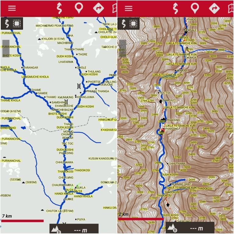
BTW, what maps do you have for Nepal? I had some of the 1:25k maps compiled from 1:50k aerial done in 1992. The other maps I bought in Kathmandu were 1:75k. I haven't found newer maps since the earthquake.

I have previously used some Garmin maps from these fellas who did some good maps for Annapurna, Everest, Helambu/Langtang http://www.nepal-trilogy.de/index.php/e ... s-gps.html Good mapset but some waypoints are in German, and the last update was in 2015. Garmin maps don't display the best on Oruxmaps, but they give some idea if you want to give these maps a crack.

They look better on Garmins, but this is what they look like on Oruxmaps.
Nepal Trilogy Maps (Medium).jpg
Nepal Trilogy Maps (Medium).jpg (233.28 KiB) Viewed 17919 times

Re: Georeferencing a Jpeg Map

PostPosted: Fri 05 Jul, 2019 10:01 am
by tastrax
The most important thing is to find out what formats the android device accepts, and then make sure that your georeferencing software can produce that format. If not, it may be a multistep process with different software.

Re: Georeferencing a Jpeg Map

PostPosted: Fri 05 Jul, 2019 12:55 pm
by johnrs
Thanks very much guys for your detailed suggestions.
I have a feeling this may be beyond me,
Are there local mapping companies that do this stuff for a reasonable fee?
(A bit like a surveyors office)
Thanks again
john

Re: Georeferencing a Jpeg Map

PostPosted: Fri 05 Jul, 2019 2:02 pm
by tastrax
Give us some more details John - It may not be that hard!

Which app are you using or thinking of using?
Have a look at the jpeg files - is there another file with the same name... map001.jpg and maybe map001.jpgw? They may actually be ready to use already (in some programs)

Re: Georeferencing a Jpeg Map

PostPosted: Fri 05 Jul, 2019 3:14 pm
by johnrs
Thanks Phil
The digital maps bought are the Great Himalaya trail series by Robin Boustred.
The technical details: datum, coordinate systems and others are referenced on the maps.
viz Everest 1937 datum, 1830 coordinate system and many more details
There is also some system of grid markings.
In addition Robin makes available a series of waypoints for the GHT as GPX files,
I think these waypoints could be overlaid to provide accurate georeferencing,
The phone app we most use is Avenza on Android phones.
My GHT group is based in Hobart although I could send you more map details privately?
I have no technical mapping experience, just an old walker.
A bit more here
http://greathimalayatrail.com/gpsFiles.php
http://www.greathimalayatrail.com/ghtProducts.php
Thanks
John

Re: Georeferencing a Jpeg Map

PostPosted: Tue 09 Jul, 2019 4:08 pm
by ken333
Oruxmaps Desktop for Windows is fairly easy to use. If you have GPX waypoints, you can open the GPX files with Notepad, or other text editor, to get the lat/lons of the waypoints. You can copy-paste these into Google Earth to identify where they are, and find the corresponding points on your maps. You can get the pixel positions of the points on your jpeg map by opening the jpeg with MSPaint, or other image editor that shows pixel position of the cursor. MSPaint measures pixel position from top-left corner, whereas Oruxmaps Desktop requires the bottom-left corner, so subtract the y value from the image height.These pixel positions and lat/lons can be typed or copy-pasted into the calibration boxes of Oruxmaps Desktop. The Datum for GPX is WGS84. Then copy-paste the folder produced into the oruxmaps/map files folder on the Android.
Oruxmaps (for Android) takes a bit of getting used to. There are tutorials on the web that will take you through the steps. See Keithy's post.
OziExplorer has an image import and calibration function. You need lat/lon and pixel positions of each calibration point, as above.

Re: Georeferencing a Jpeg Map

PostPosted: Wed 10 Jul, 2019 11:03 am
by johnrs
Thanks for all the suggestions here folks.
This will not be a quick project,
Thanks
John

Re: Georeferencing a Jpeg Map

PostPosted: Thu 11 Jul, 2019 11:22 am
by tastrax
No luck so far at my end - the jpeg map needs to be warped to make the waypoints fit and in doing so you lose some of the resolution of the original image. I will keep plugging away as I get time.

More waypoint files here

https://drive.google.com/drive/folders/ ... EvkemR2vKk

https://www.himalayanadventurelabs.com/ ... yan-trail/

Re: Georeferencing a Jpeg Map

PostPosted: Sun 04 Aug, 2019 1:23 am
by ribuck
I have found a really easy way to georeference a JPG on Android, using the Custom Maps app (free from the Google Play app store). There's an easy-to-follow tutorial here:
http://www.custommapsapp.com/tutorial

It's a little fiddly to do it all on the small phone screen the first time, but after that it's a piece of cake.

Once you have georeferenced the JPG, the Custom Maps app will use the phones's GPS to display your current position on it, but there are no other navigation functions. For that you need to export the georeferenced map, in the form of a KMZ overlay file. And that's where I've drawn a blank - I can't get the KMZ to display in OruxMaps.

But the actual georeferencing was straightforward - just pick up to four points on your JPG, then slide a transparent overlay of Google Maps until each point lines up.

Re: Georeferencing a Jpeg Map

PostPosted: Sun 04 Aug, 2019 12:02 pm
by michael_p
Apparently this can be done in Google Earth Pro: https://support.google.com/earth/answer/148099?hl=en