Free maps - Contour Aus matched with Open Street Map (OSM)

For all high tech electronic equipment including GPS, PLB, chargers, phones, computers, software. Discussion of simple electrical devices such as torches, belongs in the main 'Equipment' forum.

Re: Free maps - Contour Aus matched with Open Street Map (OS

Postby Ent » Sun 09 Sep, 2012 2:40 pm

Hi NNW

But it is that! Well at least now it is :wink: Poor speller and tiny text box with aging eyesight do not make the Ent a good naming specialist.

Cheers
"lt only took six years. From now on, l´ll write two letters a week instead of one."
(Shawshank Redemption)
User avatar
Ent
Lagarostrobos franklinii
 
Posts: 4086
Joined: Tue 13 May, 2008 3:38 pm
Region: Tasmania

Re: Free maps - Contour Aus matched with Open Street Map (OS

Postby Ent » Mon 24 Sep, 2012 7:10 pm

A great weekend walking around the Lake Mackenzie area with one of Blue Peaks bagged and a stay at the large lake next to Middle Lake. Does that lake have a name? The next day this was followed by a walk around the north side of the lake to join up with the Unimog track and out again. Saturday good weather and Sunday rain, followed by heavy rain, followed by heavy wind blown rain, followed by a massive temperature drop and heavy snow. Yeap, Tassie if you do not like the weather wait five minutes.

As the only techie on the walk chance to use the GPS with OSM maps and Contour Australia without the crutch of a electronic form of Tasmaps. Had of course the paper map as backup plus a walker well experienced in the area in the group. As the walk took us past an old foundation I took the chance to waypoint the building corners and the centre with the hope that it would show up on Bing so I could have a reference point to align the Bing aerial photograph to. Ok maybe only a mapping freak would find such a foundation exciting.
IMG_0347.JPG
Any reference point will do.


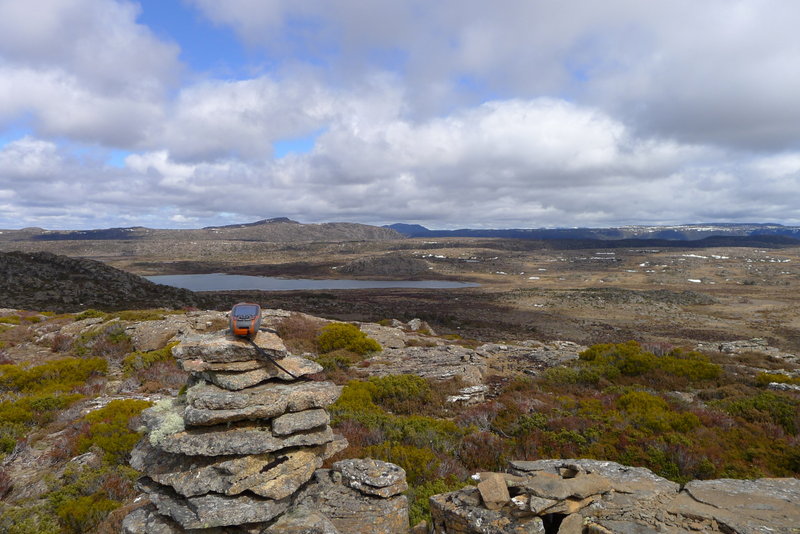
Blue Peak 1 was easily reached as the off track walking in that area is very friendly so managed to dodge the scree and scrub. The view from Blue Peak 1 was great and a chance to play with the waypoint averaging feature of the Garmin 62S. My position differed a little to the one on this site peak list but not by much.
P1060382.JPG
Not such a bad view to take in while the Garmin does its averaging trick.


So it was on to the camping spot. The old hand took us via the scenic route as memory is not what it used to be was the excuse. I found the tarn on the GPS that I had traced in but it was not the one. Then we found the lake but it was not on my GPS? Um? Did I miss it. Err no, I mucked up and while I had traced it in I did not have it marked as a lake :oops: But what the heck good chance to walk the lake and get the GPS plot plus the waypoints to reference and align Bing with. Err? walking around an alpine lake can have a few challenges but managed not to do a closer in water survey.
P1060436.JPG
It is a hell of a job checking a lake's position but someone has to do it.


Woke the next day and it was pretty much clagged in. This is where I found the old school versus new school thinking collided. The old school is to reverse the route and using the recent memory to back track. New school was, heck we know where we are so lets strike out for a track and then follow that back. New school won so away we went.
IMG_0355.JPG
It was a misty walk but easy to get to the track.


Once on track we encountered a rather well marked secondary track that mislead us. Thanks to the GPS we could back track and take the same way back. As it turned out the "false" track was arguably the better option but we did not know that as heavy snow was falling the and the temperature plummeting. So we made it back to the car.

Now the homework stated with the lakes being aligned to known GPS position, track put into OSM along with the road up to Lake Mackenzie. Still more fix up work required but very happy that home made maps can work well in the real world. Tasmap's track is rather off by over a hundred if not two hundred metres so hopefully the amateur maps are better than the professional ones.

Cheers
"lt only took six years. From now on, l´ll write two letters a week instead of one."
(Shawshank Redemption)
User avatar
Ent
Lagarostrobos franklinii
 
Posts: 4086
Joined: Tue 13 May, 2008 3:38 pm
Region: Tasmania

Re: Free maps - Contour Aus matched with Open Street Map (OS

Postby Ent » Mon 15 Oct, 2012 1:55 pm

Well the Garmin 62s managed to find the 9,172nd way to annoy me. I downloaded from OSM Australia the latest Garmin maps but instead of deleting the old ones from my 62S decided just to re-name them. Err, Um? What happened to all my work of updating the tracks and the lakes around the Dove Lake to Lake Rodway area? Yeap, I fell for it. Garmin use the information and their name in the file to give you ability to select the map to make active, not the actual file name. So have two img files with the same meta data and bingo Garmin appears to use the oldest one. Aside from the Ent standard temper tantrum until the penny dropped that I had out of interest downloaded the "no name street" highlighted set as well so had at least one current version of OSM maps.

Once made active I was mighty impressed by the accuracy. I took averaged waypoint locations on the visitor information hut in Dove Lake carpark and various lakes and visible to satellite structures to complete the alignment (still to put up on OSM) but even based on the rough alignment I did from the tracks to the photographs I was well within 10 metres from my lake tracing efforts. In fact pretty much within the 2.5 metre accuracy that Garmin maps can theoretically give.

In all very happy with OSM as a mapping tool and more importantly a navigation tool. Even rebuilt the road into Cradle that was lost in the great data redaction of OSM so it could meet the most open of licences. Now the more mad mappers out there the better and quicker the maps will become. Where the data exists they make standard Garmin maps look rather average.

Also my new case for the Garmin that does not have the magnetic latch meant that the compass after recalibration worked a treat. Starting to become a very happy camper with the Garmin 62s and OSM.

Cheers.
"lt only took six years. From now on, l´ll write two letters a week instead of one."
(Shawshank Redemption)
User avatar
Ent
Lagarostrobos franklinii
 
Posts: 4086
Joined: Tue 13 May, 2008 3:38 pm
Region: Tasmania

Re: Free maps - Contour Aus matched with Open Street Map (OS

Postby Ent » Sat 27 Oct, 2012 3:48 pm

The much anticipated wander from the Moses Creek Track via Mount Spurling to Mount Ida and then down to Narcissus was done with the usual array of navigational equipment It was a good test of the Garmin 62s loaded with OSM and Contour Australia 5m. Lot of work was done beforehand tracing lakes from Bing but as people familiar with this area only a percentage could be done.

The added bonus was the Garmin Fenix turned up a day before so had a chance to load OSM on it . This proved to be very capable of following the track with. Used both GPSs to log the track but yet to upload the plots to OSM to refine the Moses Creek Track . The good weather meant it was possible to followed the track and avoid the mid winter missed turns from pervious wanders. Also found the track up to Lake Artemis easy to follow and will upload it to OSM.

While the main tool was the Nexus running Tasmaps the Garmin 62s was very handy getting a sense of place. More work is required to have sufficient information loaded into OSM to be a replacement for maps. The contours assisted in understanding the terrain but are rather imprecise to identify cliff lines. But then we found Tasmap not exactly accurate either as wound up in a cliff lined valley. Also Tasmap has the Moses Creek Track in the wrong place.

Currently with OSM the main advantage is the ability to meet up with uploaded tracks. In all a useful tool that will only become more useful as people contribute to the knowledge base.

Cheers
"lt only took six years. From now on, l´ll write two letters a week instead of one."
(Shawshank Redemption)
User avatar
Ent
Lagarostrobos franklinii
 
Posts: 4086
Joined: Tue 13 May, 2008 3:38 pm
Region: Tasmania

Re: Free maps - Contour Aus matched with Open Street Map (OS

Postby gayet » Sat 03 Nov, 2012 9:49 am

HELP

I have the latest OSM img file for TAS, thanks photohiker and Ent, but I am completely ignorant of how to get it onto my GPS. Seems the laptop can't recognise the GPS when plugged in - Mapsource doesn't like img files and I am not a hardware initiate. :roll:

I have Shonky OK, but OSM is defeating me. I need to get it on there tonight. I have tried img2gps but that still leaves me with an img file. Or is this what I want and I shouldn't be trying to load it as a map?

:oops:

All fixed. Thanks photohiker!
gayet
Phyllocladus aspleniifolius
 
Posts: 960
Joined: Sat 12 Feb, 2011 8:01 pm
Location: Wallan
Region: Victoria
Gender: Female

Re: Free maps - Contour Aus matched with Open Street Map (OS

Postby Ent » Sat 03 Nov, 2012 10:10 pm

Hi

Good news all fixed. Currently at one of Basil Steers Huts thanks to OSM. But bit cold so best head inside.

Cheers.
"lt only took six years. From now on, l´ll write two letters a week instead of one."
(Shawshank Redemption)
User avatar
Ent
Lagarostrobos franklinii
 
Posts: 4086
Joined: Tue 13 May, 2008 3:38 pm
Region: Tasmania

Re: Free maps - Contour Aus matched with Open Street Map (OS

Postby Ent » Sat 10 Nov, 2012 9:36 am

At long last got around to putting in the GPS trace from Junction Lake Hut to Lake Artemis. The track is well marked by cairns on the ground and appears on Tasmap as an approximate route. Also reworked the track from Mersey River Road up to Junction Lake to fix up missed turns.

Fixed up a few roads in the Borridale area and noticed that Tasmap's new 1:25,000 edition maps are a lot clearer in the printing and have much improved detail in that and the February Plains area. This a good thing as for while there their maps were going backwards. Hope this new found vigor continues but sadly they have lost their way on the electronic map release so we Tasmanains still have third world electronic options. Trying out the lamination done at the Map Shop in Hobart to see if it improves map life which is pathetic due to the lousy paper Tasmap insist on using. Just wish that they would bite the bullet and go for the same paper used on the waterproof OLT map. The lamination does not make for a folding friendly map and the on first glance the lamination done at Burnie's Xerox shop looks a better option.

So gradually adding in lakes, huts and tracks and finding OSM becoming very useful as the database grows. Was great to aim for the OLT when coming down the Traveller Range and found OSM plus Contour Australia a useful tool on the trip. The accuracy it gives (providing that the data is right) is brilliant compared to Tasmap. While Tasmap is improving I am now very wary of taking their track positions as anything more than a guide and have noticed even a few sizable water bodies have been missed.

Also had a play with the compass and map just to learn how much I have forgotten. Err, Um? Dangerous be I now :shock:

Cheers
"lt only took six years. From now on, l´ll write two letters a week instead of one."
(Shawshank Redemption)
User avatar
Ent
Lagarostrobos franklinii
 
Posts: 4086
Joined: Tue 13 May, 2008 3:38 pm
Region: Tasmania

Re: Free maps - Contour Aus matched with Open Street Map (OS

Postby greyim » Sat 27 Jul, 2013 8:06 am

How's it going... Does this OSM data load onto a garmin ok? and what is the procedure?
Nothing beats a nice camp fire
greyim
Athrotaxis cupressoides
 
Posts: 235
Joined: Fri 27 Mar, 2009 6:23 pm
Region: Tasmania

Re: Free maps - Contour Aus matched with Open Street Map (OS

Postby Ent » Sat 27 Jul, 2013 8:35 am

greyim wrote:How's it going... Does this OSM data load onto a garmin ok? and what is the procedure?


Hi

I have been working at expanding the project to provide one simple file with OSM data and combined. Check out http://www.bushwalk.com/forum/viewtopic ... 4&start=30 as that has links to the img and I have even written a Readme guide.

Cheers
"lt only took six years. From now on, l´ll write two letters a week instead of one."
(Shawshank Redemption)
User avatar
Ent
Lagarostrobos franklinii
 
Posts: 4086
Joined: Tue 13 May, 2008 3:38 pm
Region: Tasmania

Re: Free maps - Contour Aus matched with Open Street Map (OS

Postby greyim » Sat 27 Jul, 2013 12:03 pm

thanks Ent
Nothing beats a nice camp fire
greyim
Athrotaxis cupressoides
 
Posts: 235
Joined: Fri 27 Mar, 2009 6:23 pm
Region: Tasmania

Re: Free maps - Contour Aus matched with Open Street Map (OS

Postby AWHS » Sun 20 Mar, 2016 11:29 pm

Thanks for this great explanation of where OSM comes from, I have often wondered.

For example, looking at the Wolgan Valley east of Newnes on OSM here
http://www.openstreetmap.org/#map=15/-33.1782/150.2649&layers=CND

It looks reasonable, contours all line up etc...

CaptureOSM_Wolgan.PNG


But if you look at NSW data here for Newnes you get a very different view
http://maps.six.nsw.gov.au/

CaptureNSWSIX_Wolgan.PNG


The actual valley itself looks like this
http://www.pointhacks.com.au/wp-content/uploads/2014/12/Emirates-Wolgan-Valley-Scenery-4.jpeg

Wolgan-Valley-Scenery-4.jpeg


Clearly the OSM contour data is fabricated and has significant limitations. I was very interested to read the posts above that it originally came from satellite radar data. Perhaps it is of better quality elsewhere but in this particular part of the world it is actually dangerous! Until I sat down and looked at this area I never realised how approximate the contours are. So the problem with OSM is that the price is undeniably highly attractive but it is really a trap. I am finding it useful because there are tracks and other features on OSM that are missing in other mapsets but it really needs to be treated with caution!
AWHS
Nothofagus cunninghamii
 
Posts: 1
Joined: Thu 11 Feb, 2016 6:58 pm
Region: New South Wales
Gender: Male

Re: Free maps - Contour Aus matched with Open Street Map (OS

Postby GPSGuided » Mon 21 Mar, 2016 8:53 am

The cycling OSM map uses a lot of smoothing and I am not even sure of the source of their contour data, a bit like what one find through Google. So definitely not what you want. To use OSM for bushwalks, you need to use those that are paired with better quality topo datasets. One example being Andrewp's compilation as discussed in another thread. Or use OSM's official download and combine it with a transparent topo overlay in your Garmin unit. Unfortunately the transparent topo overlay file is 2G in size and the original uploader no longer supports or offer it. You may still be able to obtain a copy through a friend somewhere.

http://tinyurl.com/osm-maps
Just move it!
User avatar
GPSGuided
Lagarostrobos franklinii
 
Posts: 6968
Joined: Mon 13 May, 2013 2:37 pm
Location: Sydney
Region: New South Wales

Re: Free maps - Contour Aus matched with Open Street Map (OS

Postby photohiker » Mon 21 Mar, 2016 10:58 am

AWHS wrote:Clearly the OSM contour data is fabricated and has significant limitations. I was very interested to read the posts above that it originally came from satellite radar data. Perhaps it is of better quality elsewhere but in this particular part of the world it is actually dangerous! Until I sat down and looked at this area I never realised how approximate the contours are. So the problem with OSM is that the price is undeniably highly attractive but it is really a trap. I am finding it useful because there are tracks and other features on OSM that are missing in other mapsets but it really needs to be treated with caution!


I wouldn't call OSM contour data 'fabricated'. That is a step too far IMO. It comes from the SRTM data as far as I know, and sure, it generally doesn't show cliffs. If you are willing to walk with your eyes only on your GPS there are plenty of things you will trip over other than cliffs! It is dangerous to walk without your wits about you, yes. Any 'traps' are of your own making, OSM is just one of many tools you can use to make a 'trap' for yourself if you are so inclined.

The best combination is OSM and printed maps and a compass IMO. OSM being maintained by the walking public means it has tracks that are often not found on printed maps.

If you are prepared to improve OSM, why don't you go and put those cliffs in the OSM data? Once they are there, all users of OSM traversing the area will benefit. Here is a link to 'Cliff' in the OSM Wiki: http://wiki.openstreetmap.org/wiki/Tag:natural%3Dcliff
Michael
User avatar
photohiker
Lagarostrobos franklinii
 
Posts: 3130
Joined: Sun 17 May, 2009 12:31 pm
Location: Adelaide, dreaming up where to go next.

Re: Free maps - Contour Aus matched with Open Street Map (OS

Postby tqc » Mon 21 Mar, 2016 11:25 am

I thought it was just the cliff data at first glance too, but it goes beyond that. Look at the contours close to the cliff lines - very close together on one map, a gentle slope on the other. There is clearly some heavy interpolation happening.

Maybe it's technically accurate in some sense, but it's somewhere between useless and outright dangerous for any sort of off-track route finding.
tqc
Nothofagus gunnii
Nothofagus gunnii
 
Posts: 21
Joined: Mon 29 Feb, 2016 11:30 am
Region: New South Wales
Gender: Male

Re: Free maps - Contour Aus matched with Open Street Map (OS

Postby GPSGuided » Mon 21 Mar, 2016 11:33 am

TQC, as said, there's a lot of smoothing with the OSM Cycle Map, they were never designed for critical off track Bushwalk needs. It's like picking up a tourist map. For cyclists (road, touring, MTB), those contours are more than adequate. You just picked the wrong OSM version for your application. As for cliff lines, they are in the base OSM dataset,different versions of OSM may or may not display that feature. As said, use the appropriate version of OSM for your application.


Sent from my iPad using Tapatalk
Just move it!
User avatar
GPSGuided
Lagarostrobos franklinii
 
Posts: 6968
Joined: Mon 13 May, 2013 2:37 pm
Location: Sydney
Region: New South Wales

Re: Free maps - Contour Aus matched with Open Street Map (OS

Postby photohiker » Mon 21 Mar, 2016 12:47 pm

I don't know what the fuss is all about. Bushwalkers need to be aware of their surroundings.

In any case, it would appear that the OSM community is already mapping the cliffs in that valley. Just a matter of time before it hits the user output:

Image
Michael
User avatar
photohiker
Lagarostrobos franklinii
 
Posts: 3130
Joined: Sun 17 May, 2009 12:31 pm
Location: Adelaide, dreaming up where to go next.

Re: Free maps - Contour Aus matched with Open Street Map (OS

Postby GPSGuided » Mon 21 Mar, 2016 1:03 pm

Different OSM implementations can have different sets of data to display. Some of them don't display cliff lines and I believe OSM Cycling is one such.
Just move it!
User avatar
GPSGuided
Lagarostrobos franklinii
 
Posts: 6968
Joined: Mon 13 May, 2013 2:37 pm
Location: Sydney
Region: New South Wales

Re: Free maps - Contour Aus matched with Open Street Map (OS

Postby photohiker » Mon 21 Mar, 2016 2:35 pm

Correct GPSG. All it takes is any person who creates the output from the OSM data to decide to include the cliffs.

That could include anyone making OSM GPS Bushwalking maps.
Michael
User avatar
photohiker
Lagarostrobos franklinii
 
Posts: 3130
Joined: Sun 17 May, 2009 12:31 pm
Location: Adelaide, dreaming up where to go next.

Previous

Return to Techno-Babble

Who is online

Users browsing this forum: No registered users and 24 guests